| Grubebach | |
|---|---|
 | |
| Location | |
| Country | Germany |
| State | North Rhine-Westphalia |
| Physical characteristics | |
| Source | |
| • coordinates | 51°47′57″N 8°37′13″E / 51.79917°N 8.62028°E |
| Mouth | |
• location | Ems |
• coordinates | 51°49′11″N 8°21′40″E / 51.8198°N 8.3610°E |
| Length | 22.2 km (13.8 mi) [1] |
| Basin features | |
| Progression | Ems→ North Sea |
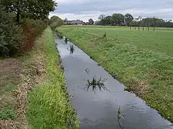
Grubebach (in its lower course: Bokel-Mastholter Hauptkanal) is a river of North Rhine-Westphalia, Germany. It flows into the Ems near Rheda-Wiedenbrück.
See also
References
This article is issued from Wikipedia. The text is licensed under Creative Commons - Attribution - Sharealike. Additional terms may apply for the media files.