Guadalupe, Colorado | |
|---|---|
 Guadalupe Plaza | |
| Etymology: Named for the Virgen of Guadalupe | |
| Nickname: Guadalupe Plaza | |
 Guadalupe, Colorado Location of Guadalupe in Colorado  Guadalupe, Colorado Guadalupe, Colorado (the United States) | |
| Coordinates: 37°5′43″N 106°1′32″W / 37.09528°N 106.02556°W[1] | |
| Country | |
| State | |
| County | Conejos County |
| Elevation | 7,900 ft (2,400 m) |
| Time zone | UTC-7 (MST) |
| • Summer (DST) | UTC-6 (MDT) |
| ZIP code | 81129 |
| Area code | 719 |
Guadalupe is an unincorporated community in Conejos County, in the U.S. state of Colorado.[1]
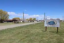
The community, which is centered on a grassy plaza, is located on the north bank of the Conejos River, just north of Conejos, Colorado, along Conejos County Road 13.
History
Guadalupe was among the first settlements in the San Luis Valley. It was founded by Lafayette Head in 1854.[2]
Guadalupe served as the Conejos County county seat from 1861 — when the county was established — until 1863, when the county seat was moved to nearby and slightly higher Conejos, due to flooding from the Conejos River in Guadalupe.[3]
References
- 1 2 3 "Guadalupe". Geographic Names Information System. United States Geological Survey, United States Department of the Interior. October 13, 1978. Retrieved May 18, 2021.
- ↑ Lanier, Claire L. (August 21, 2015). "Lafayette Head". Colorado Encyclopedia. Retrieved May 18, 2021.
- ↑ Noel, Thomas J.; Zuber-Mallison, Carol (2015). Colorado: A historical atlas. Norman: University of Oklahoma Press. pp. 74–75. ISBN 9780806141848.
This article is issued from Wikipedia. The text is licensed under Creative Commons - Attribution - Sharealike. Additional terms may apply for the media files.
