| Ha Wo Hang | |||||||||
|---|---|---|---|---|---|---|---|---|---|
| Traditional Chinese | 下禾坑 | ||||||||
| Cantonese Yale | hah wòh hāang | ||||||||
| |||||||||

Ha Wo Hang (Chinese: 下禾坑; lit. 'lower Wo Hang', with Wo Hang meaning "valley of rice")[1] is a village in Wo Hang, Sha Tau Kok, in the North District of Hong Kong. Part of the village is a walled village.
Administration
Ha Wo Hang is a recognized village under the New Territories Small House Policy.[2] It is one of the villages represented within the Sha Tau Kok District Rural Committee. For electoral purposes, Ha Wo Hang is part of the Sha Ta constituency, which is currently represented by Ko Wai-kei.[3][4]
History
Ha Wo Hang was established in 1730 by members of the Hakka Li Clan, branching out from the nearby village of Sheung Wo Hang.[5]
At the time of the 1911 census, the population of Ha Wo Hang was 160. The number of males was 66.[6]
Built heritage
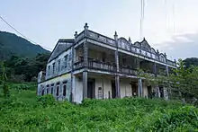
Fat Tat Tong (發達堂), at Nos. 1–5, was built in 1933. It is a Grade I historic building.[7][8]
See also
References
- ↑ Antiquities and Monuments Office: Leaflet about the Kang Yung Study Hall
- ↑ "List of Recognized Villages under the New Territories Small House Policy" (PDF). Lands Department. September 2009.
- ↑ "Recommended District Council Constituency Areas (North District)" (PDF). Electoral Affairs Commission. Retrieved 19 October 2021.
- ↑ "North District Council - North DC Members". District Council. Retrieved 19 October 2021.
- ↑ Antiquities and Monuments Office: Brief information on proposed Grade Nil items. Item #1275 Archived 2013-10-22 at the Wayback Machine
- ↑ Hase, Patrick (1996). "Traditional Life in the New Territories: The Evidence of the 1911 and 1921 Censuses" (PDF). Journal of the Royal Asiatic Society Hong Kong Branch. 36: 77. ISSN 1991-7295.
- ↑ Antiquities and Monuments Office: List of the 1,444 Historic Buildings in Building Assessment Archived 2018-06-18 at the Wayback Machine
- ↑ Antiquities and Monuments Office: Brief Information on proposed Grade III Items. Item #762 Archived 2013-09-22 at the Wayback Machine
External links
- Delineation of area of existing village Ha Wo Hang (Sha Tau Kok) for election of resident representative (2019 to 2022)
- Antiquities and Monuments Office. Hong Kong Traditional Chinese Architectural Information System. Ha Wo Hang Tsuen
22°31′38″N 114°11′55″E / 22.527322°N 114.198658°E