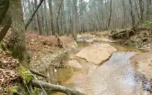
Haleys Branch
| Haleys Branch Tributary to Crabtree Creek | |
|---|---|
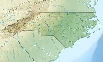 Location of Haleys Branch mouth  Haleys Branch (Crabtree Creek tributary) (the United States) | |
| Location | |
| Country | United States |
| State | North Carolina |
| County | Wake |
| City | Raleigh |
| Physical characteristics | |
| Source | divide between Haleys Branch and Little Brier Creek |
| • location | just south of Raleigh-Durham (RDU) airport |
| • coordinates | 35°52′07″N 078°47′05″W / 35.86861°N 78.78472°W[1] |
| • elevation | 358 ft (109 m)[2] |
| Mouth | Crabtree Creek |
• location | Lake Crabtree |
• coordinates | 35°50′18″N 078°47′04″W / 35.83833°N 78.78444°W[1] |
• elevation | 272 ft (83 m)[1] |
| Length | 2.33 mi (3.75 km)[3] |
| Basin size | 2.19 square miles (5.7 km2)[4] |
| Discharge | |
| • location | Crabtree Creek |
| • average | 2.51 cu ft/s (0.071 m3/s) at mouth with Crabtree Creek[4] |
| Basin features | |
| Progression | Crabtree Creek → Neuse River → Pamlico Sound → Atlantic Ocean |
| River system | Neuse River |
| Tributaries | |
| • left | unnamed tributaries |
| • right | unnamed tributaries |
| Waterbodies | Lake Crabtree |
Haleys Branch is a tributary to Crabtree Creek that rises just south of the Raleigh-Durham (RDU) airport then flows south to meet Crabtree Creek in Lake Crabtree.[2] The watershed is about 68% forested.
See also
References
- 1 2 3 "GNIS Detail - Haleys Branch". geonames.usgs.gov. US Geological Survey. Retrieved 14 September 2019.
- 1 2 "Reedy Creek Topo Map, Wake County NC (Raleigh West Area)". TopoZone. Locality, LLC. Retrieved 14 September 2019.
- ↑ "ArcGIS Web Application". epa.maps.arcgis.com. US EPA. Retrieved 14 September 2019.
- 1 2 "Haleys Branch Watershed Report". Waters Geoviewer. US EPA. Retrieved 14 September 2019.
External links
This article is issued from Wikipedia. The text is licensed under Creative Commons - Attribution - Sharealike. Additional terms may apply for the media files.