Harris, North Carolina | |
|---|---|
 Harris  Harris | |
| Coordinates: 35°14′34″N 81°52′28″W / 35.24278°N 81.87444°W | |
| Country | United States |
| State | North Carolina |
| County | Rutherford |
| Elevation | 791 ft (241 m) |
| Time zone | UTC-5 (Eastern (EST)) |
| • Summer (DST) | UTC-4 (EDT) |
| ZIP code | 28074 |
| Area code | 828 |
| GNIS feature ID | 1024024[1] |
Harris is an unincorporated community in Rutherford County, North Carolina, United States. The community is located along a railroad south of U.S. Route 221 and 10 miles (16 km) south-southeast of Rutherfordton. Harris has a post office with ZIP code 28074.[2][3]
References
- ↑ "Harris". Geographic Names Information System. United States Geological Survey, United States Department of the Interior.
- ↑ United States Postal Service (2012). "USPS - Look Up a ZIP Code". Retrieved February 6, 2015.
- ↑ "Postmaster Finder - Post Offices by ZIP Code". United States Postal Service. Retrieved February 6, 2015.
Municipalities and communities of Rutherford County, North Carolina, United States | ||
|---|---|---|
| Towns | 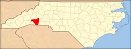 | |
| Village | ||
| CDPs | ||
| Unincorporated communities | ||
This article is issued from Wikipedia. The text is licensed under Creative Commons - Attribution - Sharealike. Additional terms may apply for the media files.