Hebao Island
荷包岛 | |
|---|---|
Island | |
| Hebao Dao | |
 | |
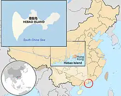
 Locator map of Hebao Island in China | |
| Coordinates: 21°51′52″N 113°09′33″E / 21.86444°N 113.15917°E | |
| Country | China |
| Province | Guangdong |
| Area | |
| • Total | 13 km2 (5 sq mi) |
Hebao Island (Chinese: 荷包岛[1] Hebao Dao,[2] literally "Purse Island", variants: Bullock Horn,[3] Ho-pao,[4] Ho-pao Tao,[5] Kukok Island,[6] Kukok Ngao Kok,[7] Niu-chiao-shan[8] and Niu-chio Tao[9]) is a resort island off the southern coast of Guangdong province in the People's Republic of China. Located in the South China Sea, it is approximately 100 kilometers West-Southwest of Hong Kong.
Administratively, this picturesque, sub-tropical island belongs to the prefecture-level city of Zhuhai, and so may be considered part of the so-called Chinese Riviera. It has a total area of 13 square kilometers, and its coast consists mainly of beaches,[10] while the interior includes sub-tropical forest.[11]
Four-mile long Great South beach (Chinese: 荷包岛大南湾沙滩) is the longest on the island.[12]
See also
References
- ↑ "荷包岛: China". Retrieved 2010-10-04.
- ↑ "Hebao Dao: China". Retrieved 2010-10-04.
- ↑ "Bullock Horn: China". Retrieved 2010-10-04.
- ↑ "Ho-pao: China". Retrieved 2010-10-04.
- ↑ "Ho-pao Tao: China". Retrieved 2010-10-04.
- ↑ "Kukok Island: China". Retrieved 2010-10-04.
- ↑ "Kukok Ngao Kok: China". Retrieved 2010-10-04.
- ↑ "Niu-chiao-shan: China". Retrieved 2010-10-04.
- ↑ "Niu-chio Tao: China". Retrieved 2010-10-04.
- ↑ "荷包岛". Retrieved 2010-10-04.
- ↑ "Zhuhai purse Island". Archived from the original on 2010-09-22. Retrieved 2010-10-04.
- ↑ "珠海荷包岛". Retrieved 2010-10-04.