| Heder | |
|---|---|
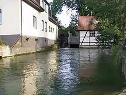
 the Header shortly after her source at Upsprunge (a district of Salzkotten) | |
| Location | |
| Country | Germany |
| State | North Rhine-Westphalia |
| Physical characteristics | |
| Source | |
| • coordinates | 51°39′14″N 8°36′01″E / 51.6540°N 8.6003°E |
| Mouth | |
• location | into the Lippe |
• coordinates | 51°42′35″N 8°31′20″E / 51.7096°N 8.5221°E |
| Basin features | |
| Progression | Lippe→ Rhine→ North Sea |
Heder is a river of North Rhine-Westphalia, Germany. It springs at Upsprunge (a district of Salzkotten).[1][2] It is a left tributary of the Lippe in Schwelle (also a district of Salzkotten).[1][3]
See also
Wikimedia Commons has media related to Heder.
References
- 1 2 "TIM-online" (in German). (Select Gewässer in the search box, then enter Heder): Abteilung 7 der Bezirksregierung Köln (may be translated as: division 7 of the administration of region Cologne). Retrieved 19 September 2019.
- ↑ Google (19 September 2019). "Heder source" (Map). Google Maps. Google. Retrieved 19 September 2019.
- ↑ Google (19 September 2019). "Heder mouth" (Map). Google Maps. Google. Retrieved 19 September 2019.
This article is issued from Wikipedia. The text is licensed under Creative Commons - Attribution - Sharealike. Additional terms may apply for the media files.