Hempens
Himpens | |
|---|---|
Village | |
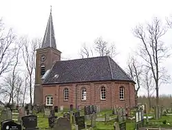 St Martin's Church | |
 Flag  Coat of arms | |
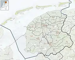 Hempens Location in the Netherlands  Hempens Hempens (Netherlands) | |
| Coordinates: 53°11′N 5°50′E / 53.183°N 5.833°E | |
| Country | |
| Province | |
| Municipality | |
| Area | |
| • Total | 0.93 km2 (0.36 sq mi) |
| Elevation | 0 m (0 ft) |
| Population (2021)[1] | |
| • Total | 285 |
| • Density | 310/km2 (790/sq mi) |
| Postal code | 9086[1] |
| Dialing code | 058 |
Hempens (West Frisian: Himpens) is a village in Leeuwarden municipality in the province of Friesland, the Netherlands.
It was first mentioned in 1463 as Hempens, and means "settlement of the people of Hempe (person)".[3]
Hempens was an agricultural community. In 1840, it was home to 89 people. The church burnt down in 1945, and was rebuilt in 1948.[4]
Gallery
 Street view with bridge in the distance
.jpg.webp) Art in Hempens
Art in Hempens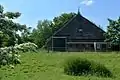 Farm in Hempens
References
- 1 2 3 "Kerncijfers wijken en buurten 2021". Central Bureau of Statistics. Retrieved 30 March 2022.
Partially with Teerns
- ↑ "Postcodetool for 9086CA". Actueel Hoogtebestand Nederland (in Dutch). Het Waterschapshuis. Retrieved 30 March 2022.
- ↑ "Hempens - (geografische naam)". Etymologiebank (in Dutch). Retrieved 30 March 2022.
- ↑ "Hempens". Plaatsengids (in Dutch). Retrieved 30 March 2022.
This article is issued from Wikipedia. The text is licensed under Creative Commons - Attribution - Sharealike. Additional terms may apply for the media files.