Herceghalom | |
|---|---|
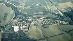 Aerial view | |
 Flag  Coat of arms | |
 Herceghalom | |
| Coordinates: 47°29′50″N 18°44′43″E / 47.49709°N 18.74519°E | |
| Country | Hungary |
| Region | Central Hungary |
| County | Pest |
| District | Budakeszi |
| Rank | Village |
| Area | |
| • Total | 7.38 km2 (2.85 sq mi) |
| Population (2017) | |
| • Total | 2,599[1] |
| Area code | 23 |
| Motorways | M1 |
| Distance from Budapest | 28.7 km (17.8 mi) East |
| Website | https://www.herceghalom.hu/ |
Herceghalom is a village in Pest county, Budapest metropolitan area, Hungary. It has a population of 3,511 (2007).
References
External links
Wikimedia Commons has media related to Herceghalom.
| Towns (4) |
| |
|---|---|---|
| Large village (1) | ||
| Villages (7) | ||


This article is issued from Wikipedia. The text is licensed under Creative Commons - Attribution - Sharealike. Additional terms may apply for the media files.