Hiattville, Kansas | |
|---|---|
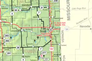 KDOT map of Bourbon County (legend) | |
| Coordinates: 37°43′20″N 94°52′18″W / 37.72222°N 94.87167°W[1] | |
| Country | United States |
| State | Kansas |
| County | Bourbon |
| Elevation | 997 ft (304 m) |
| Time zone | UTC-6 (CST) |
| • Summer (DST) | UTC-5 (CDT) |
| Area code | 620 |
| FIPS code | 20-31650 |
| GNIS ID | 474999[1] |
Hiattville is an unincorporated community in Bourbon County, Kansas, United States.[1]
History
A post office at Hiattville was established in 1870. It was first called Pawnee, but later renamed Hiattville in honor of James M. Hiatt, who owned the town site.[2] The Sedalia branch Missouri-Kansas-Texas Railroad passed through Hiattville from the 1870s until the line was abandoned in 1988.
Education
The community is served by Uniontown USD 235 public school district.
References
- 1 2 3 4 U.S. Geological Survey Geographic Names Information System: Hiattville, Kansas
- ↑ Blackmar, Frank Wilson (1912). Kansas: A Cyclopedia of State History, Embracing Events, Institutions, Industries, Counties, Cities, Towns, Prominent Persons, Etc. Standard Publishing Company. pp. 840.
Further reading
External links
Municipalities and communities of Bourbon County, Kansas, United States | ||
|---|---|---|
| Cities | 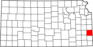 Map of Kansas highlighting Bourbon County | |
| Unincorporated communities | ||
| Townships | ||
| Footnotes | †This community is designated a Census-Designated Place (CDP) by the United States Census Bureau. ‡This community also has portions in an adjacent county or counties. | |
This article is issued from Wikipedia. The text is licensed under Creative Commons - Attribution - Sharealike. Additional terms may apply for the media files.