| Hillman Perth, Western Australia | |||||||||||||||
|---|---|---|---|---|---|---|---|---|---|---|---|---|---|---|---|
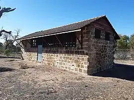
 The historic Dixon Road Abattoir | |||||||||||||||
| Coordinates | 32°16′41″S 115°46′08″E / 32.278°S 115.769°E | ||||||||||||||
| Population | 1,807 (SAL 2021)[1] | ||||||||||||||
| Postcode(s) | 6168 | ||||||||||||||
| Area | 1.2 km2 (0.5 sq mi)[2] | ||||||||||||||
| LGA(s) | City of Rockingham | ||||||||||||||
| State electorate(s) | Rockingham, Kwinana | ||||||||||||||
| Federal division(s) | Brand | ||||||||||||||
| |||||||||||||||
Hillman is an outer southern suburb of Perth, the capital city of Western Australia, located within the City of Rockingham. It is principally a suburb of residential dwellings, and contains Hillman Primary School.
The suburb was created and named in 1970 after Alfred Hillman, a draughtsman, surveyor and explorer, who arrived in Western Australia in 1831 and made many initial surveys in the Rockingham area.[3] On 7 May 2009, a boundary realignment of Cooloongup and Hillman approved by the Minister for Lands incorporated the Rockingham Train Station into Rockingham.
A significant portion of the north and east portions of the suburb is incorporated into Rockingham Lakes Regional Park.
References
- ↑ Australian Bureau of Statistics (28 June 2022). "Hillman (suburb and locality)". Australian Census 2021 QuickStats. Retrieved 28 June 2022.
- ↑ Australian Bureau of Statistics (27 June 2017). "2016 Community Profiles: Hillman (State Suburb)". 2016 Census of Population and Housing. Retrieved 26 November 2021.
- ↑ "History of metropolitan suburb names – H". Western Australian Land Information Authority. Archived from the original on 16 March 2022. Retrieved 13 October 2008.
This article is issued from Wikipedia. The text is licensed under Creative Commons - Attribution - Sharealike. Additional terms may apply for the media files.