Hoarafushi
ހޯރަފުށި | |
|---|---|
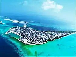
 An aerial view of the island | |
 Hoarafushi Location in Maldives | |
| Coordinates: 6°58′50″N 72°53′45″E / 6.98056°N 72.89583°E | |
| Country | Maldives |
| Geographic atoll | Ihavandhippolhu Atoll |
| Administrative atoll | Haa Alif Atoll |
| Distance to Malé | 317.57 km (197.33 mi) |
| Government | |
| • Council | Secretariat of the Hoarafushi Council |
| Dimensions | |
| • Length | 1.75 km (1.09 mi) |
| • Width | 0.45 km (0.28 mi) |
| Population (2019)[1] | |
| • Total | 4,500 (excluding foreigners) |
| Time zone | UTC+05:00 (MST) |
| Area code(s) | 650, 20 |

Hoarafushi (Dhivehi: ހޯރަފުށި ) is an inhabited island of Haa Alif Atoll, Maldives, and is geographically part of the Ihavandhippolhu Atoll. The island is famous for its scenic attractions. Hoarafushi Airport was established in 2020. It is an island-level administrative constituency governed by the Hoarafushi Island Council.
History
The island is named after the great frigatebird, known as the hoara in Dhivehi, which used to be seen there.
According to the 1912 census, Hoarafushi was the fourth-largest locality in the Maldives, with a population of 1,811.[2] The island used to be an educational hub. The people of Hoarafushi claim to have originated from Gudhanfushi, a vanished island adjacent to Huvahandhoo in the same reef. The population moved to Huvuhandhoo as Gudhanfushi eroded away before moving onto Hoarafushi. In 2006 the inhabitants of Berinmadhoo were relocated to Hoarafushi.
Geography
Hoarafushi is located at the northern most Ihavandhippolhu Atoll. The island is situated within the largest fringing reef of Maldives extending over 22 km. Hoarafushi consist of 3 islands naturally joined the main island Hoarafushi adjacent to Bodufinolhu connected in the late (1700) and Kudafinolhu in (2013). The island has a land area of 105 hectares. 317.57 km (197 mi; 171 nmi) north of the country's capital, Malé.[3]
Population
| Year | Pop. | ±% |
|---|---|---|
| 1912 | 1,811 | — |
| 1921 | 1,177 | −35.0% |
| 1931 | 1,602 | +36.1% |
| 1985 | 1,650 | +3.0% |
| 1990 | 1,995 | +20.9% |
| 1995 | 2,098 | +5.2% |
| 2000 | 2,221 | +5.9% |
| 2006 | 2,204 | −0.8% |
| 2014 | 3,291 | +49.3% |
| 2016 | 3,388 | +2.9% |
| 2018 | 4,379 | +29.3% |
| 2019 | 4,500 | +2.8% |
| 1911-2014-2016-2019-2021: Census populations Source: [4] | ||
Education
The Hoarafushi island has 4 well known educational institutions.
- H.a Atoll School (ހ.އ އަތޮޅު މަދަރުސާ), a government manipulated educational institution. (LKG to Grade 12)
- Adam Saleem Hadhaanee Pre-school (އާދަމް ސަލީމް ހަދާނީ ޕްރީ ސްކޫލް), Private. (Kindergarten)
- Thauleemul Bayaan (ތައުލީމުލް ބަޔާން), a private educational institution mainly focused on Qur'an Studies.
- Novel Institute of Technology offers IT courses[5]
References
- ↑ "Table PP5: Resident Population by sex, nationality and locality (administrative islands), 2014" (PDF). Population and Households Census 2014. National Bureau of Statistics. p. 33. Retrieved 9 August 2018.
- ↑ "National Bureau of statistics". Retrieved 8 August 2014.
- ↑ "Coordinate Distance Calculator". Boulter.com. Retrieved 9 August 2018.
- ↑ "Table 3.3: Total Maldivian Population by Islands" (PDF). National Bureau of Statistics. Retrieved 9 August 2018.
- ↑ "Isles - Hoarafushi". isles.gov.mv.