Hofkirchen im Mühlkreis | |
|---|---|
 | |
 Coat of arms | |
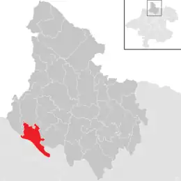 Location in the district | |
 Hofkirchen im Mühlkreis Location within Austria | |
| Coordinates: 48°29′02″N 13°48′43″E / 48.48389°N 13.81194°E | |
| Country | Austria |
| State | Upper Austria |
| District | Rohrbach |
| Government | |
| • Mayor | Martin Raab (ÖVP) |
| Area | |
| • Total | 22.68 km2 (8.76 sq mi) |
| Elevation | 601 m (1,972 ft) |
| Population (2018-01-01)[2] | |
| • Total | 1,520 |
| • Density | 67/km2 (170/sq mi) |
| Time zone | UTC+1 (CET) |
| • Summer (DST) | UTC+2 (CEST) |
| Postal code | 4142 |
| Area code | 0 72 85 |
| Vehicle registration | RO |
| Website | www.hofkirchen.at |
Hofkirchen im Mühlkreis is a municipality in the district of Rohrbach in the Austrian state of Upper Austria.
Population
| Year | Pop. | ±% |
|---|---|---|
| 1869 | 1,515 | — |
| 1880 | 1,522 | +0.5% |
| 1890 | 1,406 | −7.6% |
| 1900 | 1,305 | −7.2% |
| 1910 | 1,312 | +0.5% |
| 1923 | 1,336 | +1.8% |
| 1934 | 1,346 | +0.7% |
| 1939 | 1,403 | +4.2% |
| 1951 | 1,336 | −4.8% |
| 1961 | 1,384 | +3.6% |
| 1971 | 1,339 | −3.3% |
| 1981 | 1,415 | +5.7% |
| 1991 | 1,427 | +0.8% |
| 2001 | 1,436 | +0.6% |
| 2011 | 1,423 | −0.9% |
| 2017 | 1,511 | +6.2% |
References
- ↑ "Dauersiedlungsraum der Gemeinden Politischen Bezirke und Bundesländer - Gebietsstand 1.1.2018". Statistics Austria. Retrieved 10 March 2019.
- ↑ "Einwohnerzahl 1.1.2018 nach Gemeinden mit Status, Gebietsstand 1.1.2018". Statistics Austria. Retrieved 9 March 2019.
Wikimedia Commons has media related to Hofkirchen im Mühlkreis.
This article is issued from Wikipedia. The text is licensed under Creative Commons - Attribution - Sharealike. Additional terms may apply for the media files.