Homer Township, Buchanan County | |
|---|---|
 | |
| Coordinates: 42°20′46″N 091°53′27″W / 42.34611°N 91.89083°W | |
| Country | |
| State | |
| County | Buchanan |
| Area | |
| • Total | 36.14 sq mi (93.6 km2) |
| • Land | 36.14 sq mi (93.6 km2) |
| • Water | 0 sq mi (0 km2) |
| Elevation | 915 ft (279 m) |
| Population (2000) | |
| • Total | 681 |
| • Density | 18.8/sq mi (7.3/km2) |
| FIPS code | 19-91977[2] |
| GNIS feature ID | 0468050 |
Homer Township is one of 16 townships in Buchanan County, Iowa, USA. As of the 2000 census, its population was 681. Homer Township was organized in 1858.[3]
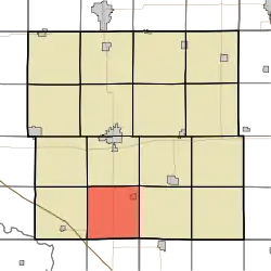
Geography
Homer Township covers an area of 36.14 square miles (93.6 km2) and contains one incorporated settlement, Rowley. According to the USGS, it contains two cemeteries: Clayton and Rowley.
References
- ↑ "US Board on Geographic Names". United States Geological Survey. October 25, 2007. Retrieved January 31, 2008.
- ↑ "U.S. Census website". United States Census Bureau. Retrieved January 31, 2008.
- ↑ History of Homer Township
External links
Municipalities and communities of Buchanan County, Iowa, United States | ||
|---|---|---|
| Cities | Map of Iowa highlighting Buchanan County | |
| Townships | ||
| Unincorporated communities | ||
| Ghost towns | ||
| Footnotes | ‡This populated place also has portions in an adjacent county or counties | |
This article is issued from Wikipedia. The text is licensed under Creative Commons - Attribution - Sharealike. Additional terms may apply for the media files.