Hopin
ဟိုပင် | |
|---|---|
Town | |
 | |
 Hopin Location in Burma | |
| Coordinates: 24°59′0″N 96°31′0″E / 24.98333°N 96.51667°E | |
| Country | |
| Division | |
| District | Mohnyin District |
| Township | Mohnyin Township |
| Population | |
| • Religions | Buddhism Christianity |
| Time zone | UTC+6.30 (MST) |
| WOEID | 1017418 |

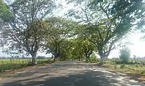
ဟိုပင် မှ ကြာကြီးကွင်း
Hopin (Burmese: ဟိုပင်မြို့; Shan: ဝဵင်းႁူဝ်ပၢင်ႇ; also Hobin) is a town in Mohnyin Township, Kachin State, in north-east Myanmar. It is situated on the main Mandalay – Myitkyina railway line, 745 miles north from Yangon. It is on the road between Mohnyin and Mogaung where the road to Ywathit and Indawgyi Lake takes off. It is 27 miles by road from Indawgyi Lake[1] and 60 miles by road from Sinbo which is located on the west bank of the Ayeyarwady River.
Notes
- ↑ "Indawgyi Lake Wildlife Sanctuary". Ministry of Ecotourism. Archived from the original on 2006-03-25. Retrieved 2008-12-25.
External links
- "Hopin Map — Satellite Images of Hopin" Maplandia World Gazetteer
This article is issued from Wikipedia. The text is licensed under Creative Commons - Attribution - Sharealike. Additional terms may apply for the media files.

