Horopito railway station | |||||||||||
|---|---|---|---|---|---|---|---|---|---|---|---|
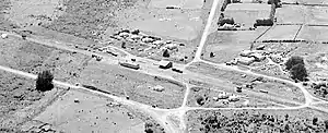 Horopito in 1957 | |||||||||||
| General information | |||||||||||
| Location | New Zealand | ||||||||||
| Coordinates | 39°20′37″S 175°22′41″E / 39.343657°S 175.378017°E | ||||||||||
| Elevation | 752 m (2,467 ft) | ||||||||||
| Line(s) | North Island Main Trunk | ||||||||||
| Distance | Wellington 327.5 km (203.5 mi) | ||||||||||
| History | |||||||||||
| Opened | in use from 31 May 1907 goods 12 August 1907 passengers 15 February 1909 | ||||||||||
| Closed | goods 19 September 1986 passengers before December 1975 | ||||||||||
| Electrified | June 1988 | ||||||||||
| Services | |||||||||||
| |||||||||||
Horopito was a station on the North Island Main Trunk line,[1] in the Ruapehu District of New Zealand. It served the small village of Horopito and lies just to the north of two of the five largest NIMT viaducts. It and Pokaka also lay to the south of Makatote Viaduct, the late completion of which held up opening of the station.
A passing loop remains at the station site.[2]
History
Surveying for the route between Hīhītahi and Piriaka began in 1894.[3] The line opened from Waiouru to Rangataua for goods traffic on 12 August 1907[4] and a mail coach ran between the railheads at Raurimu and Rangataua, serving Horopito on the way.[5] A stationmaster was appointed by March 1908.[4]
A telephone line from the north was in place by 1907, but a link to Mataroa was not installed until 1909.
In August 1908 Horopito was the point where engines were changed on the first through train, to reduce its weight to negotiate the still unballasted track to the north.[6]
Work on the station building began in November 1908.[7] A 5th class station was built by September 1909 for around £3,340.[4] When opened, Horopito had rooms for a stationmaster, lobby, luggage, urinals and ladies, on a 300 ft (91 m) by 15 ft (4.6 m) platform. There was also an engine shed, a 40 ft (12 m) by 30 ft (9.1 m) goods shed with verandah, two 4,000 imp gal (18,000 L; 4,800 US gal) water tanks, a loading bank, cattle and sheep yards and a cart approach. There was a tablet and fixed signals. Railway workers cottages were built from 1907. A crossing loop could take 60 wagons, extended to 80 in 1955. Electric lighting was installed after 1924.[4]
The station building was replaced by a prefabricated shelter shed in 1971. On 19 September 1986 the station closed to all traffic.[4]
Gallery
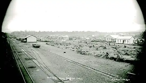 Horopito station about 1910
 Changing the tablet at Horopito Railway Station, with an X class in 1920.
 Horse-drawn timber wagon hauling a log to a mill at Horopito in 1921
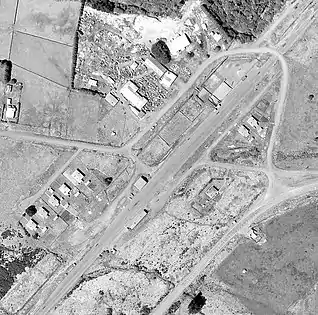 Horopito in 1964
Timber
Like the other stations along this part of NIMT, Horopito had freight from several timber mills.
R A Wilson & Co had a mill about 3 mi (4.8 km) from the station,[8] linked by a private siding from 1908.[4] Berg Brothers had a mill from at least 1908[9] to 1921,[10] with a horse-drawn tramway.[11] A tramway to the Mangaturuturu valley was still in use in 1938.[12] Mr Harland built a mill for cutting manoao into sleepers in 1909.[13] In 1912 Silver Pine Timber Co opened a mill for the same timber about 1 mi (1.6 km) from the station.[14] Cowern & Co had several tramways east of the station. Another sawmill had a short tramway south of the station.[15] Orata Mill burnt down in the 1918 Raetihi fire,[16] but was still working in 1924.[17]
Taonui viaduct | |
|---|---|
 Taonui Viaduct in 1908 | |
| Coordinates | 39°22′06″S 175°22′18″E / 39.36842°S 175.37166°E |
| Carries | Single track of the North Island Main Trunk |
| Crosses | Taonui Stream |
| Owner | Department of Conservation |
| Characteristics | |
| Total length | 400 feet (120 m) |
| Height | 111 feet (34 m) |
| History | |
| Engineering design by | PWD |
| Construction start | 1906 |
| Opened | February 1908 |
| Replaced by | 29 June 1987 reinforced concrete viaduct 100 metres (330 ft) long and 20 metres (66 ft) high |
| Designated | 27 March 2009 |
| Reference no. | 9266 |
Viaducts
Two of NIMT's main viaducts are to the south of Horopito, where the line crosses valleys descending steeply from Mount Ruapehu. Both were designed by Peter Seton Hay, supervised by Resident Engineer, Frederick William Furkert, both had 201 m (659 ft) radius curves, and both were replaced on 29 June 1987 by a 10 km (6.2 mi) deviation, begun in 1984. As early as the 1960s there had been calls to bypass the viaducts, as they'd had a 20 mph (32 km/h) speed restriction, due to their tight radius, since the 1930s. Hapuawhenua Viaduct would have also required costly underpinning. The old viaducts were transferred to the Department of Conservation, in a like for like swap of land between DoC and the Railways Department.[18] From Saturday 14 February 2009[19] they became part of the Mountains to Sea Trail.[20]
Both viaducts are made up of lattice steel piers on concrete footings, supporting 36 ft (11m) plate steel spans, interspersed with 64 ft (20m) Pratt truss steel girders. The lattice piers were built a tier at a time, using guy lines attached to derricks. Access to the pier heads was by ladder. The pier head girders weighed about 3½ tons, and the truss girders 9½ tons. They were positioned with derricks. The steelwork was prepared at PWD's Mangaonoho workshop, near the southernmost of the main viaducts. It was railed northwards to the Hapuawhenua valley floor, over a temporary, sharply curved and graded,[21] 1 mi 48 ch (2.6 km) line from Ohakune, which was built in 1906.[22] Material for Taonui was then carted along the coach road.[18]
There are also bridges over one of the tributaries of the Toanui, and a, bridge over the Makotuku River,[23] which is just south of Horopito.[24] Makotuku Viaduct was one of those on NIMT built by Andersons of Christchurch.[25] Hapuawhenua, or Mole, Tunnel was 10.3 ch (680 ft; 210 m) long and also bypassed in 1987.[26]
.jpg.webp)
Taonui Viaduct
About 2.5 km (1.6 mi) south of Horopito,[27] Taonui Viaduct is a straight concrete viaduct, 100 m (330 ft) long and up to 20 m (66 ft) high.[15] It replaced the original curved viaduct, to the west.[28]
That viaduct, further down the Taonui Stream, opened in February 1908. It is 400 ft (120 m) long and up to 111 ft (34 m) above the stream, on a 1 in 60 gradient. It has 3 steel piers supportlng the central spans. The southern end has a concrete pier and abutments.[18] Taonui was decked by February 1908, allowing coach passengers to walk across, while their coach wound around the road below. It was the first of 5 viaducts in the last portion of the NIMT to be finished, but the rails couldn't be linked to Ohakune until Hapuawhenua was ready in April 1908.[18]
On 18 and 19 March 1918 the Raetihi Fire damaged 70 ft (21 m) of sleepers, some of the parapet and set a truck on a goods train alight. The only significant additions were strengthening in 1934 and 1971.[18]
After the deviation opened, the rails and decking were removed and some of the cuttings leading to it were filled with spoil from the new deviation. When the listing report was done in 2009, almost all the red-lead primer, last applied in 1964, was exposed and there was some rusting. There was also a comment that the footings could be adversely affected by moisture trapped by the vegetation.[18] Plans to route the cycle trail over the viaduct have been shelved.[29]
Hapuawhenua viaduct | |
|---|---|
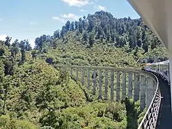 Northern Explorer on Hapuawhenua Viaduct in 2012 | |
| Coordinates | 39°23′06″S 175°23′58″E / 39.38503°S 175.39955°E |
| Carries | Single track of the North Island Main Trunk |
| Crosses | Hapuawhenua Stream |
| Owner | KiwiRail |
| Characteristics | |
| Total length | 284 metres (932 ft) |
| Height | 45 metres (148 ft) |
| History | |
| Engineering design by | PWD |
| Construction start | 1906 |
| Construction end | April 1908 |
| Replaced by | 29 June 1987 reinforced concrete viaduct 414 metres (1,358 ft) long and up to 51 metres (167 ft) high |
| Designated | 27 October 1995 |
| Reference no. | 7271 |
| Location | |
Hapuawhenua Viaduct
A further 2.5 km (1.6 mi) south,[30] Hapuawhenua Viaduct is built of reinforced and pre-stressed concrete, 414 m (1,358 ft) long and up to 51 m (167 ft) high. It too was rebuilt in 1987.[31]
Further up the Hapuawhenua Stream, to the east, remains the viaduct completed in April 1908. It is 284 m (932 ft) long and up to 45 m (148 ft) high.[15] It used 7,430 cu yd (5,680 m3) of concrete, 1,252 tons of steel and 26,560 board feet (62.7 m3) of timber.[32]
By August 1907 the preparation of the Hapuawhenua site was complete and excavation of the footings began. Abutments and 13 concrete piers were complete by December 1907. Work had also begun on the 4 central steel piers, which were finished in January 1908.[33]
Strengthening was done between 1925 and 1934, and again in 1971. It was painted in 1964, and telephone wire insulators were added to the western side.[33]
When the deviation opened in 1987 the rails were removed and a walkway created using old sleepers and a new handrail.[33]
In 1988 the viaduct was used by AJ Hackett for what may have been the first commercial bungy jumping in the world.[33]
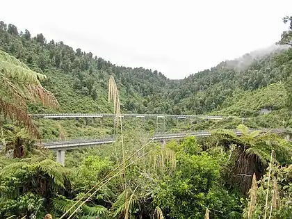 Hapuawhenua viaducts - 1908 at the back, 1987 in front
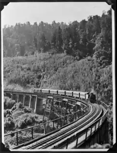 Hapuawhenua Viaduct about 1915
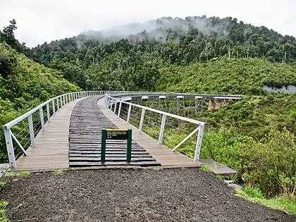 Hapuawhenua 1908 viaduct from the north
Old Coach Road
15 km (9.3 mi) of the Makatote-Ohakune Old Coach Road has been restored between Horopito and Ohakune.[20] It mostly followed the route (with the exception of the section to Taonui Viaduct) of a bridle track completed in 1886, which had been upgraded to a dray road in 1895. It was mostly paved between 1904 and November 1906, mainly with setts to create an all-weather road for construction material along the line. From 11 November 1906[34] it was also used to carry passengers and goods between the northern and southern railheads, though as late as May 1907 there were complaints of mud making some parts impassable.[35] However, a month later the road was described as very good[36] and a daily coach was covering the 28 mi (45 km) between Raurimu and Rangataua.[37] From 1 November 1907 Ohakune became the southern terminal.[38] Early in 1908 the northern terminal advanced to Waimarino (National Park), reducing the coach distance to 22 mi (35 km).[39] In May 1908 the northern terminus became Makatote, with the coach trip reduced to 10 mi (16 km).[40] About 2 mi (3.2 km) of the road was not paved,[41] being covered only with pumice.[42] After the opening of SH49 it fell into disuse. Like the viaducts, it has a Category I Historic Places status, though much later, from 5 October 2004,[34] and was re-opened from 2009 as part of a cycle trail.[29]
References
- ↑ Scoble, Juliet. "Names & Opening & Closing Dates of Railway Stations in New Zealand 1863 to 2010" (PDF). Rail Heritage Trust of New Zealand.
- ↑ "40 Matapuna Rd". Google Maps. Retrieved 18 December 2020.
- ↑ "THE RAURIMU SPIRAL. NEW ZEALAND HERALD". paperspast.natlib.govt.nz. 1 November 1929. Retrieved 11 October 2020.
- 1 2 3 4 5 6 "Stations" (PDF). NZR Rolling Stock Lists. Retrieved 10 August 2020.
- ↑ "NORTH ISLAND MAIN TRUNK RAILWAY. MANAWATU STANDARD". paperspast.natlib.govt.nz. 7 October 1907. Retrieved 18 December 2020.
- ↑ "LINKED UP. AUCKLAND STAR". paperspast.natlib.govt.nz. 10 August 1908. Retrieved 20 December 2020.
- ↑ "MAIN TRUNK LINE. MANAWATU HERALD". paperspast.natlib.govt.nz. 26 November 1908. Retrieved 22 November 2020.
- ↑ "FROM OHAKUNE TO TAUMARUNUI. AUCKLAND STAR". paperspast.natlib.govt.nz. 8 December 1909. Retrieved 22 November 2020.
- ↑ "RANGITIKEI ADVOCATE AND MANAWATU ARGUS". paperspast.natlib.govt.nz. 26 July 1915. Retrieved 29 November 2020.
- ↑ "Horse-drawn rail timber wagon hauling a log to the mill at Horopito". National Library of New Zealand. 1 January 1921. Retrieved 29 November 2020.
- ↑ "THE BUSH FATALITY. TAIHAPE DAILY TIMES". paperspast.natlib.govt.nz. 17 August 1915. Retrieved 29 November 2020.
- ↑ "DEPARTMENT OF LANDS AND SURVEY. PUBLIC DOMAINS AND NATIONAL PARKS OF NEW ZEALAND". paperspast.natlib.govt.nz. 1 August 1939. Retrieved 20 December 2020.
- ↑ "MANAWATU STANDARD". paperspast.natlib.govt.nz. 22 October 1909. Retrieved 22 November 2020.
- ↑ "CUTTING SILVER PINE. NEW ZEALAND HERALD". paperspast.natlib.govt.nz. 3 July 1912. Retrieved 22 November 2020.
- 1 2 3 New Zealand Railway and Tramway Atlas (Fourth ed.). Quail Map Co. 1993. ISBN 0-900609-92-3.
- ↑ "THE REMAINS OF THE ORATA MILL, HOROPITO. OTAGO WITNESS". paperspast.natlib.govt.nz. 3 April 1918. Retrieved 29 November 2020.
- ↑ "TIMBER MILL FATALITY. WAIPA POST". paperspast.natlib.govt.nz. 25 March 1924. Retrieved 29 November 2020.
- 1 2 3 4 5 6 "Taonui Viaduct". heritage.org.nz. Retrieved 28 November 2020.
- ↑ "Hapuawhenua Viaduct". Project Tongariro. Retrieved 24 December 2020.
- 1 2 "Ohakune Old Coach Road". Mountains to Sea Cycle Trail. Retrieved 23 December 2020.
- ↑ "PROGRESS OF THE MAIN TRUNK LINE. FEILDING STAR". paperspast.natlib.govt.nz. 24 June 1907. Retrieved 19 December 2020.
- ↑ "PUBLIC WORKS STATEMENT. BY THE HON. JAMES McGOWAN, ACTING MINISTER FOR PUBLIC WORKS". paperspast.natlib.govt.nz. 8 November 1907. Retrieved 19 December 2020.
- ↑ "MAIN TRUNK LINE. NEW ZEALAND TIMES". paperspast.natlib.govt.nz. 1 February 1907. Retrieved 23 December 2020.
- ↑ "40 Matapuna Rd". Google Maps. Retrieved 23 December 2020.
- ↑ "83 YEARS OF AGE. PRESS". paperspast.natlib.govt.nz. 10 May 1933. Retrieved 24 December 2020.
- ↑ McLintock, Alexander Hare; R.W.S; Taonga, New Zealand Ministry for Culture and Heritage Te Manatu. "TUNNELS, RAIL AND ROAD". An encyclopaedia of New Zealand, edited by A. H. McLintock, 1966. Retrieved 23 December 2020.
- ↑ "Horopito, Manawatu-Wanganui". NZ Topo Map. Retrieved 30 November 2020.
- ↑ "Manawatū Whanganui Rural Aerial Photos". basemaps.linz.govt.nz. 2016–2017. Retrieved 22 December 2020.
- 1 2 "Historic Ohakune Old Coach Road". doc.govt.nz. Retrieved 28 November 2020.
- ↑ "Hapuawhenua Viaduct, Manawatu-Wanganui". NZ Topo Map. Retrieved 30 November 2020.
- ↑ "Hāpuawhenua Viaduct | Engineering New Zealand". www.engineeringnz.org. Retrieved 22 December 2020.
- ↑ "AUCKLAND-WELLINGTON RAILWAY. AUCKLAND STAR". paperspast.natlib.govt.nz. 6 November 1908. Retrieved 23 December 2020.
- 1 2 3 4 "Hapuawhenua Viaduct". heritage.org.nz. Retrieved 28 November 2020.
- 1 2 "Ohakune to Horopito Coach Road". heritage.org.nz. Retrieved 24 December 2020.
- ↑ "MAIN TRUNK ROADS. WANGANUI CHRONICLE". paperspast.natlib.govt.nz. 15 May 1907. Retrieved 22 December 2020.
- ↑ "WELLINGTON TO AUCKLAND. NEW ZEALAND HERALD". paperspast.natlib.govt.nz. 29 June 1907. Retrieved 22 December 2020.
- ↑ "PROGRESS ON THE MAIN TRUNK. NEW ZEALAND HERALD". paperspast.natlib.govt.nz. 25 June 1907. Retrieved 23 December 2020.
- ↑ "MANAWATU TIMES". paperspast.natlib.govt.nz. 1 November 1907. Retrieved 23 December 2020.
- ↑ "AUCKLAND STAR". paperspast.natlib.govt.nz. 27 January 1908. Retrieved 23 December 2020.
- ↑ "NORTH ISLAND TRUNK RAILWAY. AUCKLAND STAR". paperspast.natlib.govt.nz. 16 May 1908. Retrieved 23 December 2020.
- ↑ "THE MAIN TRUNK LINE. RANGITIKEI ADVOCATE AND MANAWATU ARGUS". paperspast.natlib.govt.nz. 16 May 1907. Retrieved 23 December 2020.
- ↑ "MAIN TRUNK RAILWAY. NEW ZEALAND HERALD". paperspast.natlib.govt.nz. 27 June 1907. Retrieved 23 December 2020.
External links
Photos –