Hraběšice | |
|---|---|
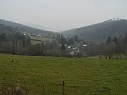 View from the east | |
 Flag  Coat of arms | |
 Hraběšice Location in the Czech Republic | |
| Coordinates: 49°58′36″N 17°4′46″E / 49.97667°N 17.07944°E | |
| Country | |
| Region | Olomouc |
| District | Šumperk |
| First mentioned | 1569 |
| Area | |
| • Total | 8.23 km2 (3.18 sq mi) |
| Elevation | 530 m (1,740 ft) |
| Population (2023-01-01)[1] | |
| • Total | 193 |
| • Density | 23/km2 (61/sq mi) |
| Time zone | UTC+1 (CET) |
| • Summer (DST) | UTC+2 (CEST) |
| Postal codes | 788 15 |
| Website | www |
Hraběšice (German: Rabenseifen) is a municipality and village in Šumperk District in the Olomouc Region of the Czech Republic. It has about 200 inhabitants.
Hraběšice lies approximately 8 kilometres (5 mi) east of Šumperk, 44 km (27 mi) north of Olomouc, and 191 km (119 mi) east of Prague.
References
Wikimedia Commons has media related to Hraběšice.
This article is issued from Wikipedia. The text is licensed under Creative Commons - Attribution - Sharealike. Additional terms may apply for the media files.