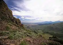
Humboldt County | |
|---|---|
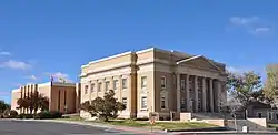 Humboldt County Courthouse in Winnemucca | |
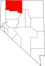 Location within the U.S. state of Nevada | |
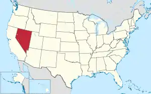 Nevada's location within the U.S. | |
| Coordinates: 41°25′N 118°07′W / 41.41°N 118.12°W | |
| Country | |
| State | |
| Founded | 1856 |
| Named for | Humboldt River |
| Seat | Winnemucca |
| Largest city | Winnemucca |
| Area | |
| • Total | 9,658 sq mi (25,010 km2) |
| • Land | 9,641 sq mi (24,970 km2) |
| • Water | 17 sq mi (40 km2) 0.2% |
| Population (2020) | |
| • Total | 17,285 |
| • Density | 1.8/sq mi (0.69/km2) |
| Time zone | UTC−8 (Pacific) |
| • Summer (DST) | UTC−7 (PDT) |
| Congressional district | 2nd |
| Website | hcnv |
Humboldt County is a county in the U.S. state of Nevada. As of the 2020 Census, the population was 17,285.[1] It is a largely rural county that is sparsely populated with the only major city being Winnemucca which has a population of 8,431.[2] Humboldt County comprises the Winnemucca, NV Micropolitan Statistical Area and serves as an important crossroads in the national transportation network. Interstate 80 travels through the southeastern corner of the county, meeting US 95 in Winnemucca that serves as a primary freight corridor between Northern Nevada and Boise, Idaho and the Interstate 84 freight corridor that links much of the Pacific Northwest. The original transcontinental railway, constructed by the Central Pacific Railroad, reached Humboldt County on Sept. 16, 1868.[3] The Western Pacific Railroad would reach Humboldt County by November 1909,[4] providing two mainline rail links to California and the Eastern United States. Both railroads have since been acquired by the Union Pacific Railroad, who continues to serve the region today.
The county contains several areas of land belonging to regionally significant Native American communities including the Fort McDermitt Paiute and Shoshone Tribe and the Winnemucca Indian Colony of Nevada.
Largely a region with ranchers and farmers, the county came under increased attention after the 2017 proposal of the Thacker Pass Lithium Mine. The mine has been controversial locally and in the national press—as it would be the first major lithium clay mine to open in the United States and be important to the local economy but threatens local ecosystems and indigenous heritage sites.[5][6]
History
Humboldt County is the oldest county in Nevada, created by the Utah Territorial Legislature in 1856. It was also one of Nevada's original nine counties created in 1861. The county is named after the Humboldt River, which was named by John C. Frémont, after Alexander von Humboldt, a German naturalist, traveler and statesman.[7] Humboldt never saw the places that bear his name. Unionville was the first county seat in 1861 until the mining boom died there and it was moved to Winnemucca on the transcontinental railroad line in 1873.
The county was the site of an arrest in 2000 that led to the U.S. Supreme Court decision Hiibel v. Sixth Judicial District Court of Nevada in 2004.
Humboldt County is referenced in Brandon Flowers' 2015 song "Digging Up The Heart", in which the protagonist meets "Christie, queen of Humboldt County".[8]
Geography

According to the U.S. Census Bureau, the county has an area of 9,658 square miles (25,010 km2), of which 9,641 square miles (24,970 km2) is land and 17 square miles (44 km2) (0.2%) is water.[9] It is Nevada's fourth-largest county by area.
The Santa Rosa Range runs through eastern Humboldt County. The highest point in the county, 9,731 ft (2,966 m) Granite Peak, is in the range.[10] The most topographically prominent mountain in Humboldt County is unofficially known as Dan Dobbins Peak and is in the remote Jackson Mountains.
Adjacent counties
- Harney County, Oregon - northwest
- Malheur County, Oregon - north
- Owyhee County, Idaho - northeast/Mountain Time Border
- Elko County - east
- Lander County - southeast
- Pershing County - south
- Washoe County - west
National protected areas
Reservations
The county includes land that is held by Indian reservations.
Fort McDermitt Paiute and Shoshone Tribe

The Fort McDermitt Indian Reservation spans the distance of the Nevada–Oregon border, in Humboldt County, Nevada and Malheur County, Oregon,[11] near the Quinn River, which runs east to west through the Tribe's Nevada lands. Just to the east is southwestern Idaho. The Fort McDermitt Military Reservation was established 14 August 1865 at the former site of Quinn River Camp No. 33 and a stagecoach stop, Quinn River Station, in what was a traditional seasonal homeland of the Paiute, Shoshone and Bannock peoples.
The reservation was established with 16,354 acres (66.2 km2) in Nevada and 19,000 acres (76.9 km2) in Oregon, mostly areas of arid land. In October 2016 the federal government put into trust for the tribe approximately 19,094 acres (77.3 km2) acres of Bureau of Land Management (BLM) land in Nevada, in order to expand their reservation and give them a more sustainable base. Gaming is prohibited on these new lands. This was done under the Nevada Native Nations Land Act (PL No: 114-232).[12]Winnemucca Indian Colony of Nevada
Demographics
| Census | Pop. | Note | %± |
|---|---|---|---|
| 1860 | 40 | — | |
| 1870 | 1,916 | 4,690.0% | |
| 1880 | 3,480 | 81.6% | |
| 1890 | 3,434 | −1.3% | |
| 1900 | 4,463 | 30.0% | |
| 1910 | 6,825 | 52.9% | |
| 1920 | 3,743 | −45.2% | |
| 1930 | 3,795 | 1.4% | |
| 1940 | 4,743 | 25.0% | |
| 1950 | 4,838 | 2.0% | |
| 1960 | 5,708 | 18.0% | |
| 1970 | 6,375 | 11.7% | |
| 1980 | 9,434 | 48.0% | |
| 1990 | 12,844 | 36.1% | |
| 2000 | 16,106 | 25.4% | |
| 2010 | 16,528 | 2.6% | |
| 2020 | 17,285 | 4.6% | |
| U.S. Decennial Census[15] 1790-1960[16] 1900-1990[17] 1990-2000[18] 2010-2018[1] | |||
2000 census
At the 2000 census there were 16,106 people in the county, organized into 5733 households, and 4133 families. The population density was 2 people per square mile (0.77 people/km2). There were 6,954 housing units at an average density of 1 units per square mile (0.39/km2). The racial makeup of the county was 83.21% White, 4.02% Native American, 0.57% Asian, 0.51% Black or African American, 0.07% Pacific Islander, 8.54% from other races, and 3.09% from two or more races. 18.87%.[19] were Hispanic or Latino of any race.
There were 5,733 households, 40.9% had children under the age of 18 living with them, 59.6% were married couples living together, 7.6% had a female householder with no husband present, and 27.9% were non-families. 22.8% of households were made up of individuals, and 6.3% had someone living alone who was 65 or older. The average household size was 2.77 and the average family size was 3.28.
The age distribution was 31.40% under the age of 18, 7.50% from 18 to 24, 31.20% from 25 to 44, 22.30% from 45 to 64, and 7.50% who were 65 or older. The median age was 33 years. For every 100 females, there were 110.30 males. For every 100 females age 18 and over, there were 110.20 males.
The median household income was $47,147 and the median family income was $52,156. Males had a median income of $44,694 versus $25,917 for females. The per capita income for the county was $19,539. 9.70% of the population and 7.70% of families were below the poverty line. Out of the total population, 10.40% of those under the age of 18 and 10.80% of those 65 and older were living below the poverty line.

2010 census
At the 2010 census, there were 16,528 people, 6,289 households, and 4,316 families in the county.[20] The population density was 1.7 inhabitants per square mile (0.66/km2). There were 7,123 housing units at an average density of 0.7 units per square mile (0.27 units/km2).[21] The racial makeup of the county was 79.0% white, 4.2% American Indian, 0.7% Asian, 0.5% black or African American, 0.1% Pacific islander, 12.7% from other races, and 2.8% from two or more races. Those of Hispanic or Latino origin made up 24.4% of the population.[20] In terms of ancestry, 15.0% were English, 14.6% were Irish, 14.1% were German, and 5.1% were American.[22]
Of the 6,289 households, 36.3% had children under the age of 18 living with them, 53.2% were married couples living together, 8.9% had a female householder with no husband present, 31.4% were non-families, and 25.6% of households were made up of individuals. The average household size was 2.60 and the average family size was 3.13. The median age was 36.2 years.[20]
The median household income was $55,656 and the median family income was $69,032. Males had a median income of $56,843 versus $33,531 for females. The per capita income for the county was $25,965. About 7.8% of families and 12.0% of the population were below the poverty line, including 17.3% of those under age 18 and 4.6% of those age 65 or over.[23]
Education
Humboldt County School District serves all of Humboldt County.[24]
Previously Crane Union High School, a boarding high school in Oregon, served portions of the county,[25] and it continues to be an option for residents living in Denio.[26]
Law enforcement
There have been at least two allegations of abuse of civil forfeiture by Humboldt County Sheriff's deputy Lee Dove. Both cases were won by the civilians in question, albeit at great personal expense.[27]
Politics
| Year | Republican | Democratic | Third party | |||
|---|---|---|---|---|---|---|
| No. | % | No. | % | No. | % | |
| 2020 | 5,877 | 75.63% | 1,689 | 21.73% | 205 | 2.64% |
| 2016 | 4,521 | 70.28% | 1,386 | 21.55% | 526 | 8.18% |
| 2012 | 3,810 | 66.33% | 1,737 | 30.24% | 197 | 3.43% |
| 2008 | 3,586 | 63.31% | 1,909 | 33.70% | 169 | 2.98% |
| 2004 | 3,896 | 72.59% | 1,361 | 25.36% | 110 | 2.05% |
| 2000 | 3,638 | 72.33% | 1,128 | 22.43% | 264 | 5.25% |
| 1996 | 2,334 | 50.85% | 1,467 | 31.96% | 789 | 17.19% |
| 1992 | 1,505 | 42.72% | 810 | 22.99% | 1,208 | 34.29% |
| 1988 | 2,378 | 66.50% | 1,024 | 28.64% | 174 | 4.87% |
| 1984 | 2,498 | 72.41% | 862 | 24.99% | 90 | 2.61% |
| 1980 | 1,950 | 68.59% | 684 | 24.06% | 209 | 7.35% |
| 1976 | 1,380 | 53.38% | 1,074 | 41.55% | 131 | 5.07% |
| 1972 | 1,659 | 69.94% | 713 | 30.06% | 0 | 0.00% |
| 1968 | 1,287 | 50.97% | 885 | 35.05% | 353 | 13.98% |
| 1964 | 1,106 | 43.77% | 1,421 | 56.23% | 0 | 0.00% |
| 1960 | 1,157 | 49.66% | 1,173 | 50.34% | 0 | 0.00% |
| 1956 | 1,292 | 60.60% | 840 | 39.40% | 0 | 0.00% |
| 1952 | 1,398 | 66.92% | 691 | 33.08% | 0 | 0.00% |
| 1948 | 901 | 49.21% | 886 | 48.39% | 44 | 2.40% |
| 1944 | 835 | 45.65% | 994 | 54.35% | 0 | 0.00% |
| 1940 | 789 | 36.60% | 1,367 | 63.40% | 0 | 0.00% |
| 1936 | 390 | 24.38% | 1,210 | 75.63% | 0 | 0.00% |
| 1932 | 405 | 26.45% | 1,126 | 73.55% | 0 | 0.00% |
| 1928 | 783 | 56.53% | 602 | 43.47% | 0 | 0.00% |
| 1924 | 400 | 35.30% | 248 | 21.89% | 485 | 42.81% |
| 1920 | 660 | 51.40% | 532 | 41.43% | 92 | 7.17% |
| 1916 | 1,004 | 33.47% | 1,681 | 56.03% | 315 | 10.50% |
| 1912 | 207 | 11.51% | 719 | 39.99% | 872 | 48.50% |
| 1908 | 823 | 40.07% | 1,009 | 49.12% | 222 | 10.81% |
| 1904 | 610 | 57.44% | 356 | 33.52% | 96 | 9.04% |
Economy
Lithium mine
The Thacker Pass Lithium Mine is a lithium clay mining development project in Humboldt County, Nevada, which is the largest known lithium deposit in the US and one of the largest in the world.[30][31][32] There has been significant exploration of Thacker Pass since 2007. The Bureau of Land Management issued a Record of Decision approving development of the mine in January 2021. Construction began in March 2023 after an emergency appeal was denied by the court.[33] The project site would cover 18,000 acres (7,300 ha), with less than 6,000 acres (2,400 ha) of that being mined,[34][35][36][37] on a site 21 miles (34 km) west-northwest of Orovada, Nevada within the McDermitt Caldera.[38][30][39] The mine is a project of Lithium Nevada, LLC - a wholly owned subsidiary of Lithium Americas Corp, whose largest shareholder is the world's largest lithium mining company, Chinese Ganfeng Lithium.[40][36] At full capacity it would produce 66,000 tons annually,[41][38][31] equivalent to 25% of the current (2021) demand for lithium globally, which is expected to triple over the next five years. Development of the mine is driven by increasing demand for lithium used in electric vehicle batteries and grid storage of intermittently generated electricity from sources such as solar power or wind power.[32][42] In late January 2023, car giant General Motors announced it would invest $650M in the mine project, giving GM exclusive access to the first phase of production.[43][44]
The project has met resistance in the form of legal challenges and direct action.[45] Several indigenous tribes with traditional homeland in the area oppose the project. These tribes have stated that Thacker Pass is a sacred site, a massacre site, and that they were not adequately consulted by the Bureau of Land Management. Opponents of the mine have voiced concerns about rushed environmental review, threats to critical wildlife habitat, disruption of cultural sites, and links between resource extraction and missing and murdered indigenous women. Proponents of the mine have stated that the project is necessary to limit climate change by reducing carbon emissions from American cars, is benign in its social and environmental impact, and will create 300 long-term jobs in rural Nevada, paying an average of $63,000 per year.[41][38] The New York Times reported that controversy around the mine is "emblematic of a fundamental tension" between green energy and damage caused by resource extraction required for those technologies.[41]Transportation
Major highways
Communities
City
- Winnemucca (county seat)
Census-designated places
Unincorporated communities
See also
References
- 1 2 "U.S. Census Bureau QuickFacts: Humboldt County, NV". United States Census Bureau QuickFacts. United States Census Bureau. Retrieved February 3, 2022.
- ↑ "U.S. Census Bureau QuickFacts: Winnemucca City". United States Census Bureau QuickFacts. Retrieved February 3, 2022.
- ↑ "The Great Race to Promontory". The Great Race to Promontory. Retrieved February 3, 2022.
- ↑ "Western Pacific in Utah". September 26, 2020. Retrieved February 3, 2022.
- ↑ Sonner, Scott (July 26, 2021). "Judge denies environmentalists' request to block digging at Thacker Pass lithium mine". Reno Gazette-Journal. Retrieved July 29, 2021.
- ↑ Great Basin Resource Watch (February 26, 2021). "Conservation and Public Accountability Groups File Legal Challenge to the Thacker Pass Lithium Mine" (PDF). Archived (PDF) from the original on February 27, 2021. Retrieved April 17, 2021.
- ↑ Gannett, Henry (1905). The Origin of Certain Place Names in the United States. Govt. Print. Off. p. 163. Retrieved January 1, 2016.
- ↑ "Brandon Flowers - Diggin' Up The Heart Lyrics". Directlyrics.com. Retrieved January 1, 2016.
- ↑ "2010 Census Gazetteer Files". United States Census Bureau. August 22, 2012. Retrieved December 20, 2014.
- ↑ "Granite Peak, Nevada". Peakbagger.com. Retrieved October 11, 2014.
- ↑ Pritzker 241
- ↑ "Nevada Native Nations Land Act" Archived 1 December 2016 at the Wayback Machine, Propublica website; accessed 30 November 2016
- ↑ Winnemucca Colony Council (March 5, 1971). "Constitution and Bylaws of the Winnemucca Indian Colony Nevada" (pdf). Harrison Loesch, Assistant Secretary of the Interior. Retrieved February 13, 2014.
- ↑ Bartell Ranch LLC, et al. Vs. Ester M. Mccullough, et al., WIC: Motion To Intervene Doc.#180 ( D. Nev. February 11, 2022) ("The Colony is a federally recognized Tribe loated in Winnemucca, Nevada. The Colony consists of 28 members whose ancestors derive from the Paiute and Shoshone Nations").
- ↑ "U.S. Decennial Census". United States Census Bureau. Retrieved December 20, 2014.
- ↑ "Historical Census Browser". University of Virginia Library. Retrieved December 20, 2014.
- ↑ "Population of Counties by Decennial Census: 1900 to 1990". United States Census Bureau. Retrieved December 20, 2014.
- ↑ "Census 2000 PHC-T-4. Ranking Tables for Counties: 1990 and 2000" (PDF). United States Census Bureau. Archived (PDF) from the original on March 27, 2010. Retrieved December 20, 2014.
- ↑ "U.S. Census website". United States Census Bureau. Retrieved January 31, 2008.
- 1 2 3 "DP-1 Profile of General Population and Housing Characteristics: 2010 Demographic Profile Data". United States Census Bureau. Archived from the original on February 13, 2020. Retrieved January 21, 2016.
- ↑ "Population, Housing Units, Area, and Density: 2010 - County". United States Census Bureau. Archived from the original on February 13, 2020. Retrieved January 21, 2016.
- ↑ "DP02 SELECTED SOCIAL CHARACTERISTICS IN THE UNITED STATES – 2006-2010 American Community Survey 5-Year Estimates". United States Census Bureau. Archived from the original on February 13, 2020. Retrieved January 21, 2016.
- ↑ "DP03 SELECTED ECONOMIC CHARACTERISTICS – 2006-2010 American Community Survey 5-Year Estimates". United States Census Bureau. Archived from the original on February 13, 2020. Retrieved January 21, 2016.
- ↑ "2020 CENSUS - SCHOOL DISTRICT REFERENCE MAP: Humboldt County, NV" (PDF). U.S. Census Bureau. Archived (PDF) from the original on July 15, 2022. Retrieved July 15, 2022. - Text list.
- ↑ Flanigan, James (March 1, 1976). "At Crane, they board 'em". The Capital Journal. Salem, Oregon. p. 12. - Clipping from Newspapers.com. There was an abbreviated version published: Flanigan, James (March 18, 1976). "Crane Union High students live on campus at Burns". The World. Coos Bay, Oregon. United Press International. p. 14. - Clipping from Newspapers.com.
- ↑ Roccapriore, Carla (December 12, 2004). "Tiny-town students visit biggest little city". Reno Gazette-Journal. pp. 1C, 2C. - Clipping of first and of second page at Newspapers.com.
- ↑ O’Harrow Jr., Robert; Sallah, Michael (September 8, 2014). "They fought the law. Who won?". The Washington Post. Retrieved September 17, 2014.
- ↑ Leip, David. "Dave Leip's Atlas of U.S. Presidential Elections". uselectionatlas.org. Retrieved April 12, 2018.
- ↑ The leading "other" candidate, Progressive Theodore Roosevelt, received 533 votes, while Socialist candidate Eugene Debs received 339 votes.
- 1 2 Bradley, Dwight C.; Stillings, Lisa L.; Jaskula, Brian W.; Munk, LeeAnn; McCauley, Andrew D. (2017). Lithium, Chapter K of Critical Mineral Resources of the United States—Economic and Environmental Geology and Prospects for Future Supply (PDF) (Report). United States Geological Survey.
- 1 2 Sonner, Scott (September 6, 2021). "Judge rejects tribes' efforts to halt digging at Thacker Pass lithium mine in Nevada". Reno Gazette Journal. Retrieved September 9, 2021.
- 1 2 Nilsen, Ella; Marsh, Rene (December 17, 2021). "A rush to mine lithium in Nevada is pitting climate advocates and environmental groups against each other". CNN. Retrieved December 17, 2021.
- ↑ Sonner, Scott (March 2, 2023). "9th Circuit denies emergency bid to halt Nevada lithium mine at Thacker Pass". KRNV-DT. Associated Press. Retrieved March 5, 2023.
- ↑ Bureau of Land Management (December 4, 2020). Thacker Pass Lithium Mine Project Final Environmental Impact Statement (PDF) (Report). Retrieved September 6, 2022.
- ↑ Burmeister, Tim. "Thacker Pass lithium project gets national spotlight". Elko Daily Free Press. Retrieved September 7, 2022.
The Thacker Pass project boundary encompasses 17,933 acres, but the land disturbance area is 5,694.8 acres.
- 1 2 Lightcap, Seth (December 6, 2021). "Thacker Pass: The Crossroads of Lithium, Wild Snow and Sacred Land". Tahoe Quarterly. p. 1. Retrieved September 7, 2022.
The mine site is slated to occupy roughly 18,000 acres, with most of that land used for processing facilities and transportation logistics. Only 5,500 acres will be actively mined over the 46 years.
- ↑ Bosler, Cayte (November 7, 2021). "Plans To Dig the Biggest Lithium Mine in the US Face Mounting Opposition". Inside Climate News.
- 1 2 3 Malmgren, Evan (September 23, 2021). "The Battle for Thacker Pass". The Nation.
- ↑ "Public Input Sought for Clay Mine". Reno Gazette-Journal. January 2, 2014.
- ↑ Investor Relations, Lithium Americas (January 17, 2017). "Lithium Americas Announces US$174 Million Strategic Investment by Ganfeng Lithium". lithiumamericas.com. Archived from the original on September 11, 2023. Retrieved September 11, 2023.
{{cite web}}: CS1 maint: date and year (link) - 1 2 3 Penn, Ivan; Lipton, Eric (May 6, 2021). "The Lithium Gold Rush: Inside the Race to Power Electric Vehicles". The New York Times. Retrieved May 22, 2021.
- ↑ Flin, Briana (December 2, 2021). "'Like putting a lithium mine on Arlington cemetery': the fight to save sacred land in Nevada". The Guardian. Retrieved December 18, 2021.
- ↑ Scheyder, Ernest (January 31, 2023). "GM to help Lithium Americas develop Nevada's Thacker Pass mine". Reuters. Retrieved February 1, 2023.
- ↑ Clifford, Catherine. "GM to invest $650 million in a lithium company to support its electric vehicle business". CNBC. Retrieved February 1, 2023.
- ↑ Stone, Maddie (March 12, 2021). "The Battle of Thacker Pass". Grist. Retrieved October 23, 2021.
