Hunstanworth is a village in County Durham, England.[1] It is situated approximately 10 miles to the west of Consett, south-west of the village of Blanchland. The population of the village as taken at the 2011 Census was 116.[2]
Listed in the Boldon Book (1183), “Robert Corbet held Hunstanworth by forest service, as is expressed in his charter of inheritance”. Other nearby lands where held by the Hospital of St Giles at Kepier to which Corbet settled his whole estate. The Hospital held the lands until the dissolution when they were passed to William Paget.[3]
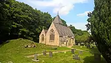
The church, dedicated to St James the Less, was built in 1781 on a medieval site.[4] The village was designed and built around the original parish church. The Reverend Daniel Capper commissioned architect Samuel Sanders Teulon to create the village in 1862-3; as well as rebuilding the church, Teulon delivered a vicarage and stable block, school and school-house and a mix of terraced, semi-detached and detached houses, all constructed of sandstone.
There are the ruins of a pele or tower house in the grounds of the church roughly dated to the 15th or 16th century.[5]
Hunstanworth is one of the Thankful Villages that suffered no fatalities during the Great War of 1914–1918. There is a carved alabaster panel on the west wall of the parish church in low relief, 'We thank thee/LORD/for bringing back/our soldiers/safely home/1914-1918'.
The nearby hamlet of Allanshields is listed in documentation from 1338, "John de Alaynsheles held a messuage and a hundred acres of arable and meadow ground in Alaynsheles".[6]
References
- ↑ Ordnance Survey: Landranger map sheet 87 Hexham & Haltwhistle (Map). Ordnance Survey. 2009. ISBN 9780319231678.
- ↑ "Parish population 2011". Retrieved 21 July 2015.
- ↑ "Parish of Hunstanworth | British History Online". www.british-history.ac.uk. Retrieved 29 June 2021.
- ↑ Historic England. "CHURCH OF ST JAMES, Hunstanworth (1229537)". National Heritage List for England. Retrieved 29 June 2021.
- ↑ Historic England. "TOWER IN CHURCHYARD OF CHURCH OF ST JAMES, Hunstanworth (1229336)". National Heritage List for England. Retrieved 29 June 2021.
- ↑ "Parish of Hunstanworth | British History Online". www.british-history.ac.uk. Retrieved 3 July 2021.
External links
![]() Media related to Hunstanworth at Wikimedia Commons
Media related to Hunstanworth at Wikimedia Commons
54°50′N 2°04′W / 54.833°N 2.067°W