
MOLA map showing boundaries of Icaria Planum and other regions. Color indicates elevation.
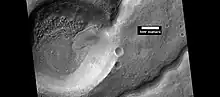
Crater and one of many nearby channels, as seen by HiRISE under HiWish program. Picture is from Icaria Planum.
Icaria Planum is a region on Mars in the Thaumasia quadrangle of Mars that is 566.59 km across and is located at 43.27 S and 253.96E. It was named after a classic albedo feature that was approved in 1979. The name of the classic feature was based on the land where according to greek mythology, Icarus died (Icaria).[1]
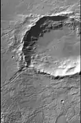 CTX image from Icaria Planum that shows location of next image.
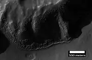 Layers in mantle deposit, as seen by HiRISE, under the HiWish program. Mantle was probably formed from snow and dust falling during a different climate.
See also
References
- ↑ C. Sagan (1980). "Editorial". Icarus. 41 (1): iii. Bibcode:1980Icar...41D...3S. doi:10.1016/0019-1035(80)90155-4.
Wikimedia Commons has media related to Icaria Planum.
| Geography | |||||||||||
|---|---|---|---|---|---|---|---|---|---|---|---|
| Astronomy |
| ||||||||||
| Exploration |
| ||||||||||
| Related | |||||||||||
| |||||||||||
This article is issued from Wikipedia. The text is licensed under Creative Commons - Attribution - Sharealike. Additional terms may apply for the media files.