Imphal East district | |
|---|---|
 | |
.svg.png.webp) Location in Manipur | |
| Coordinates: 24°48′N 93°57′E / 24.800°N 93.950°E | |
| Country | |
| State | Manipur |
| Named for | region of Imphal in the eastern side of the Imphal River |
| Headquarters | Porompat |
| Area | |
| • Total | 497 km2 (192 sq mi) |
| Population (2011) | |
| • Total | 412,275 |
| • Density | 830/km2 (2,100/sq mi) |
| Language(s) | |
| • Official | Meiteilon (officially called Manipuri)[1] |
| Time zone | UTC+5:30 (IST) |
| ISO 3166 code | IN-MN-EI |
| Vehicle registration | MN |
| Website | imphaleast |
Imphal East district (Meitei pronunciation: /ˈɪmfəl or ɪmˈfɑːl/) is one of the 16 districts of Manipur state in northeastern India. In 2011, it was the second most populous district in the state, after Imphal West.[2] In 2016, the Jiribam subdivision, which was an exclave at the western periphery of the state, was separated as an independent district.[3]
Description
The Imphal East district occupies the northeasern part of the Imphal Valley. It was created in June 1997 by dividing the erstwhile Imphal district into two parts. Prior to that, it was a subdivision of the Imphal district.[4] The hill territory of Jiribam, which was attached to the Impal East district since its formation, was separated into its own district in 2016 as part of a major reorganisation of districts.[5][3] At the same time, several hilly regions in the interior of Imphal East associated with Senapati district, were included in Imphal East.[6]
A major part of the Imphal city urban agglomeration is included in Imphal East, the rest being in Imphal West. Roughly half the population of Imphal East lives in the urban area.
The district headquarters of Imphal East is at Porompat. The total area of the district, prior to the 2016 reorganisation, was approximately 497 km2. The district is situated at an altitude 790 metres above the M.S. Level. The climate of the district is salubrious and the monsoon is tropical. The minimum temperature goes down to 0.6 degree Celsius in the winter and 41 degree Celsius in the summer. It has no rail network and hence communication is entirely dependent on road. As of 2017, a new rail line is under construction and a railway station is scheduled for completion in 2019. The district is connected via N.H. 39, N.H. 53 and N.H. 150.
Demographics
Population
| Year | Pop. | ±% |
|---|---|---|
| 1951 | 89,821 | — |
| 1961 | 135,594 | +51.0% |
| 1971 | 189,713 | +39.9% |
| 1981 | 255,365 | +34.6% |
| 1991 | 330,460 | +29.4% |
| 2001 | 394,876 | +19.5% |
| 2011 | 456,113 | +15.5% |
| 2011 Imphal East district (including the Jiribam subdivision) Source: Census of India[7] | ||
According to the 2011 census Imphal East district has a population of 456,113.[2] This gives it a ranking of 551st in India (out of a total of 640).[2] The district has a population density of 638 inhabitants per square kilometre (1,650/sq mi) .[2] Its population growth rate over the decade 2001-2011 was 14.63%.[2] Imphal East has a sex ratio of 1011 females for every 1000 males,[2] and a literacy rate of 82.81%.[2]
| Population[10] | Percentage
of Total Pop. | |
|---|---|---|
| All Scheduled Tribes | 27,657 | 6.1% |
| Kuki-Zo tribes[lower-alpha 1] | 10,737 | 2.4% |
| Naga tribes[lower-alpha 2] | 12,902 | 2.8% |
| Old Kuki/Naga[lower-alpha 3] | 3,556 | 0.8% |
After the separation of the Jiribam subdivision, the residual district has population 412,275. It has a sex ratio of 1023 females per 1000 males. 42.65% of the population live in urban areas. Scheduled Castes and Scheduled Tribes made up 2.04% and 5.38% of the population respectively.[2]
Languages
As per 2011 census, the languages spoken in Imphal East district (excluding newly created Jiribam district) are Manipuri (375,207), Nepali (6,851), Kabui (6,622), Tangkhul (4,205), and Kuki (2,066).[9]
Administrative divisions
| Sub Divisions | Tehsils/ SDC Circles |
|---|---|
| Porompat | Heingang, Porompat, Bashikhong |
| Keirao Bitra | Keirao Bitra, Tulihal |
| Sawombung | Sawombung, Sagolmang |
Recently, Jiribam district is carved out from Imphal East district comprising sub-divisions of Jiribam, Borobekra, and Babukhal.
Areas under Imphal Urban Agglomeration
Economy
Agriculture
Agriculture is the main occupation of the people in the district. There are 27,000 and 4,100 hectares of land for H.Y.V. (High Yield Variety) and improved local paddy field respectively. There are 450 hectares of land for maize, 60 hectares for wheat and 350 hectares for potato. The main food crops are paddy, potato and vegetables. Among the cash crops are sugarcane, maize, pulse, oil seed and other vegetables. The total number of workers engaged in agriculture in the district was 42,473 as per the 1991 census of which 28,661 were males and 13,812 were females. Spices like chilli, onion, ginger, turmeric and coriander of good quality are grown in the district.
| Sl. No. | Name of Crops | Area in Hect. | Production in MT |
|---|---|---|---|
| KHARIF CROPS | |||
| 1 | Paddy (HYV) | 27.00 | 80.14 |
| 2 | Local paddy | 4.10 | 5.44 |
| 3 | Maize | 0.45 | 0.80 |
| 4 | Sugar cane | 0.29 | 17.84 |
| 5 | Kharif Pulse | 0.22 | 0.26 |
| RABI CROPS | |||
| 1 | Wheat | 0.06 | 0.08 |
| 2 | Pea & other pulses | 1.53 | 1.09 |
| 3 | Potato | 0.35 | 1.52 |
| 4 | Muster & other Oilseeds crops | 0.60 | 1.22 |
Horticulture
Horticulture products have been acquiring popularity with the people in the district. Fruits like pineapple, banana, lemon and papaya grow well in the district. Pineapple grows in plenty at the slope of Ngariyan Hill. There is considerable scope for increasing the area under different horticulture crops. The soil and climate favour for mass plantation of horticulture products in the district.
The following is the areas and production of horticulture crops in the district during 1998-99.
| Sl.No. | Crops | Area in Hectare | Annual production ( M.T.) |
|---|---|---|---|
| 1 | Pineapple | 650 | 3,700 |
| 2 | Banana | 50 | 392 |
| 3 | Lemon | 56 | 224 |
| 4 | Plum, Pear & Peach | 30 | 180 |
| 5 | Papaya | 230 | 1,150 |
| 6 | Mango | 12 | 60 |
| 7 | Guava | 30 | 138 |
| 8 | Others | 250 | 397 |
| Total | 1,358 | 6,646 |
Livestock
In the district, there is a dairy farm and a veterinary training center. There are also 5 veterinary hospitals and 19 veterinary dispensaries along with three aids centers. The following is the population of livestock as per survey report of 1997 census.
| Sl. No. | Category | Total Population |
|---|---|---|
| A | LIVESTOCK | |
| 1 | Cattle | 85,964 |
| 2 | Buffaloes | 2,310 |
| 3 | Sheep | 461 |
| 4 | Goats | 2,189 |
| 5 | Horses & Ponies | 542 |
| 6 | Pigs | 10,563 |
| 7 | Dogs | 15,940 |
| 8 | Rabbits | 799 |
| B | POULTRY | |
| 1 | Cock | 30,719 |
| 2 | Hen | 2,37,704 |
| 3 | Chicken (below three months) | 1,60,018 |
| 4 | Drakes | 21,029 |
| 5 | Ducks | 35,832 |
| 6 | Ducklings ( below six months ) | 21,512 |
| 7 | Other fowls | 5,784 |
Forest
The following is the information of forest products available in the district
| Sl.No. | Items | Units | Quantity | Value (in Rs.) |
|---|---|---|---|---|
| 1 | Firewood | M.T. | 16.8 | 43.560 |
| 2 | Bamboo | nil | nil | nil |
| 3 | Charcoal | Qtl. | 1 80 | |
| 4 | Earth | C.M. | 1,060 | 16,620 |
| 5 | Stone | C.M. | 31,610 | 4,77,340 |
| 6 | Sand | C.M. | 23,542 | 3,29,685 |
Tourism
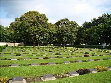
There are two motels in the district at Kaina and Jiribam. Shree-Shree Govindajee Temple, a golden temple is located in the palace compound area. There are two war cemeteries maintained by the British War Grave Commission. There is a temple at Kaina and it is a holy place of the Hindus. The Hanuman temple at Mahabali is a pre-historical place in the State.
Manipur is known for its scenic environment, landscapes, climate and cultural heritage, which has a great potential for development of tourism.
Geography
Porompat town is the administrative headquarters of the district. Nandeibam is also in the district.
Climate
| Imphal | ||||||||||||||||||||||||||||||||||||||||||||||||||||||||||||
|---|---|---|---|---|---|---|---|---|---|---|---|---|---|---|---|---|---|---|---|---|---|---|---|---|---|---|---|---|---|---|---|---|---|---|---|---|---|---|---|---|---|---|---|---|---|---|---|---|---|---|---|---|---|---|---|---|---|---|---|---|
| Climate chart (explanation) | ||||||||||||||||||||||||||||||||||||||||||||||||||||||||||||
| ||||||||||||||||||||||||||||||||||||||||||||||||||||||||||||
| ||||||||||||||||||||||||||||||||||||||||||||||||||||||||||||
See also
Notes
- ↑ The Kuki-Zo tribes include Gangte, Hmar, Paite, Simte, Sukte, Thadou, Vaiphei, Zou, and some smaller tribes designated as "Any Kuki" and "Any Lushai (Mizo)".
- ↑ The Naga tribes include Angami, Kabui, Kacha Naga, Mao, Maram, Poumai, Sema and Tangkhul.
- ↑ The Old Kuki tribes retaining the Kuki classification include: Aimol, Chiru, Kom, Koireng, Kharam, and Ralte. The tribes under the Naga umbrella include: Anal, Chothe, Koirao, Lamkang, Maring, Moyon, Monsang, Purum and Tarao.[11]
References
- ↑ "Report of the Commissioner for linguistic minorities: 47th report (July 2008 to June 2010)" (PDF). Commissioner for Linguistic Minorities, Ministry of Minority Affairs, Government of India. p. 78. Archived from the original (PDF) on 13 May 2012. Retrieved 16 February 2012.
- 1 2 3 4 5 6 7 8 "District Census Hand Book - Imphal East" (PDF). Census of India. Registrar General and Census Commissioner of India.
- 1 2 Khelen Thokchom, More districts in Manipur, The Telegraph (Kolkata), 9 December 2016. ProQuest 2290178396
- ↑ Manipur Administrative Atlas (2005), pp. 14, 36.
- ↑ Manipur Administrative Atlas (2005), p. 17.
- ↑ Imphal East district, OpenStreetMap, 14 August 2023.
- ↑ "A-2 Decadal Variation In Population Since 1901". Censusindia.gov.in. Archived from the original on 1 July 2014.
- ↑ "Table C-01 Population by religious community: Manipur". Census of India. Registrar General and Census Commissioner of India. 2011.
- 1 2 "Table C-16 Population by mother tongue: Manipur". Census of India. Registrar General and Census Commissioner of India. 2011.
- ↑ A-11 Appendix: District wise scheduled tribe population (Appendix), Manipur - 2011, Office of the Registrar General & Census Commissioner, Government of India, 2011
- ↑ Kom, Ch. Sekholal (June 2015). "Ethno-nationalism: Competing Micro-nationalist Dissents in Manipur". Social Change. 45 (2): 289–307. doi:10.1177/0049085715574192. ISSN 0049-0857.
- Sources
- Manipur Administrative Atlas (PDF), Census of India, Government of India, 2005
External links
- Imphal East district, OpenStreetMap, 14 August 2023.
- Imphal East district website
Places adjacent to Imphal East district | ||||||||||||||||
|---|---|---|---|---|---|---|---|---|---|---|---|---|---|---|---|---|
| ||||||||||||||||