Mamaku (Māori) | |
|---|---|
 Indian Island | |
| Geography | |
| Location | Dusky Sound |
| Coordinates | 45°46′40″S 166°35′20″E / 45.77778°S 166.58889°E |
| Area | 1.68 km2 (0.65 sq mi)[1] |
| Highest elevation | 196 m (643 ft) |
| Administration | |
| Demographics | |
| Population | 0 |
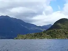
Indian Island (Māori: Mamaku) is an island in Dusky Sound in Fiordland.[2] Its name stems from first sightings of indigenous people on the island by James Cook in 1773.[3]
The island is situated southeast of Anchor Island and west of Long Island, and is part of Fiordland National Park.
Pest control of introduced animal species such as stoats and rats from 1999 onwards led to the island to be declared pest-free in 2012.[6] The island is one of only nine completely pest-free islands in Fiordland and provides another buffer to Anchor Island, which is critical to the survival of kākāpō.[7]
See also
References
- ↑ "Tamatea/Dusky Sound convervation and restoration plan" (PDF). Department of Conservation. p. 20. Retrieved 17 October 2017.
- ↑ "Indian Island, Southland - NZ Topo Map". NZ Topo Map. Land Information New Zealand. Retrieved 16 October 2017.
- ↑ "Indian Island Project". Fiordland Conservation Trust. Retrieved 16 October 2017.
- ↑ "Engraving of "Māori at Dusky Sound" by William Hodges"
- ↑ "Cook called the island ‘Indian Island’ upon account of having met and befriended Indians there"
- ↑ "Indian Island news archive". Fiordland Conservation Trust. July 2012. Retrieved 16 October 2017.
- ↑ "FCT Newsletter 'Jigsaw'" (PDF). Fiordland Conservation Trust. August 2012. Retrieved 16 October 2017.
This article is issued from Wikipedia. The text is licensed under Creative Commons - Attribution - Sharealike. Additional terms may apply for the media files.
