Inhuletskyi District
Інгулецький район (Ukrainian) | |
|---|---|
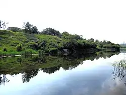 The Inhulets river flows through the district | |
 Coat of arms | |
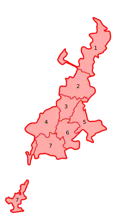 Inhuletsky District goes under number 7 | |
| Coordinates: 47°41′45″N 33°12′00″E / 47.6958°N 33.2000°E | |
| Country | |
| Region | Kryvyi Rih Municipality |
| Established | 1962 (1922 – former town of Inhulets) |
| Area | |
| • Total | 148 km2 (57 sq mi) |
| Population (2013 population estimate) | |
| • Total | 59,000 |
| • Density | 400/km2 (1,000/sq mi) |
| Time zone | UTC+2 (EET) |
| • Summer (DST) | UTC+3 (EEST) |
| Area code | 50026 |
| Website | www |
Inhuletsky District (Ukrainian: Інгуле́цький райо́н) is the southernmost urban district of Kryvyi Rih city, central-southern Ukraine. Named after the river Inhulets that flows through the area. In the year 2002, Inhuletsky District absorbed a former town of Inhulets, now it is an exclave-neighbourhood of Kryvyi Rih.
Russia-Ukrainian War
On 2 April 2022, Inhuletsky District was fired at from multiple rocket launchers Whirlwind (Smerch) by the invading Russia forces, damaging a gas station, a school and a few private living houses, resulting in no deaths.[1] Later that year, several civilians were killed by rocket attack of Russian troops on the center of the neighborhood Inhulets.
.jpg.webp)
The exclave-neighbourhood Inhulets
Population
| Year | Pop. | ±% |
|---|---|---|
| 1970 | 45,247 | — |
| 1979 | 39,053 | −13.7% |
| 1989 | 28,333 | −27.4% |
| 2001 | 23,117 | −18.4% |
| 2012 | 58,000 | +150.9% |
References
- ↑ "окупанти обстріляли з "Градів" Кривий Ріг". T1 - твій портал (in Ukrainian). Retrieved 2022-04-02.
| Villages |
| Coat of arms of Kryvyi Rih Municipality |
|---|---|---|
This article is issued from Wikipedia. The text is licensed under Creative Commons - Attribution - Sharealike. Additional terms may apply for the media files.