Ingå
Ingå – Inkoo | |
|---|---|
Municipality | |
| Ingå kommun Inkoon kunta | |
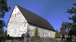
 Ingå Church | |
 Coat of arms | |
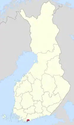
 Location of Ingå in Finland | |
| Coordinates: 60°02′44″N 24°00′17″E / 60.04556°N 24.00472°E | |
| Country | |
| Region | Uusimaa |
| Sub-region | Raseborg sub-region |
| First documents | 1335 |
| Government | |
| • Municipal manager | Jarl Boström |
| Area (2018-01-01)[1] | |
| • Total | 954.02 km2 (368.35 sq mi) |
| • Land | 350.85 km2 (135.46 sq mi) |
| • Water | 604.21 km2 (233.29 sq mi) |
| • Rank | 220th largest in Finland |
| Population (2023-09-30)[2] | |
| • Total | 5,399 |
| • Rank | 162nd largest in Finland |
| • Density | 15.39/km2 (39.9/sq mi) |
| Population by native language | |
| • Swedish | 51.9% (official) |
| • Finnish | 43.2% (official) |
| • Others | 4.9% |
| Population by age | |
| • 0 to 14 | 15.1% |
| • 15 to 64 | 59.2% |
| • 65 or older | 25.8% |
| Time zone | UTC+02:00 (EET) |
| • Summer (DST) | UTC+03:00 (EEST) |
| Climate | Dfb |
| Website | www.inga.fi |
Ingå, also known as Inkoo, (Swedish pronunciation: [ˈiŋːo]; Finnish: Inkoo, Finnish: [ˈiŋkoː]) is a municipality of Finland. It is located in the province of Southern Finland and is part of the Uusimaa region, 37 kilometres (23 mi) east of Ekenäs, the town centre of Raseborg. The municipality has a population of 5,399 (30 September 2023)[2] and covers an area of 954.02 square kilometres (368.35 sq mi) of which 604.21 km2 (233.29 sq mi) is water.[1] The population density is 15.39 inhabitants per square kilometre (39.9/sq mi).
The municipality is bilingual, with majority being Swedish and minority Finnish speakers.
Finnish national road 51 goes right through the southern part of Ingå. The centre consists mainly of the road Bollstavägen that cuts through the Ingå centrum. Along the road are most of the major buildings and shops of the small municipality. A few grocery stores, small kiosk, library and a bar. Towards the Road 51 there is the residential area. Near road 51, at the northern tip of the residential area is the Ingå Volunteer Rescue Company. Nearby villages include Kusans.
Politics
Results of the 2011 Finnish parliamentary election in Ingå:
- Swedish People's Party 41.5%
- National Coalition Party 20.3%
- Social Democratic Party 16.8%
- Finns Party 9.0%
- Green League 5.4%
- Left Alliance 2.4%
- Centre Party 1.8%
- Christian Democrats 1.5%
See also
- Karis
- Siuntio
- Inkoo virus (INKV) subtype of California encephalitis orthobunyavirus is named after the Finnish name for the area
References
- 1 2 "Area of Finnish Municipalities 1.1.2018" (PDF). National Land Survey of Finland. Retrieved 30 January 2018.
- 1 2 "Preliminary population statistics 2023, September". StatFin. Statistics Finland. Retrieved 26 October 2023.
- ↑ "Demographic Structure by area as of 31 December 2022". Statistics Finland's PX-Web databases. Statistics Finland. Retrieved 6 September 2023.
- ↑ "Population according to age (1-year) and sex by area and the regional division of each statistical reference year, 2003–2020". StatFin. Statistics Finland. Retrieved 2 May 2021.
External links
 Media related to Ingå at Wikimedia Commons
 Ingå travel guide from Wikivoyage
- Municipality of Ingå – Official website
- The Cannons at Torp Museum
