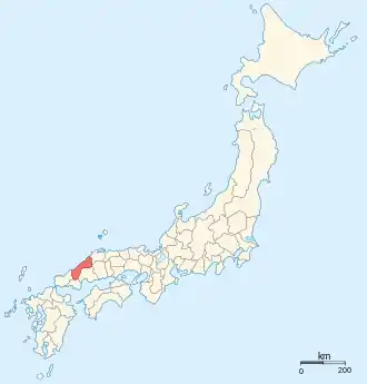
Iwami Province (石見国, Iwami-no kuni) was an old province of Japan in the area that is today the western part of Shimane Prefecture.[1] It was sometimes called Sekishū (石州). Iwami bordered Aki, Bingo, Izumo, Nagato, and Suō provinces.
In the Heian period (794–1192) the capital was at modern-day Hamada. In the Kamakura period (1192–1333) the Masuda clan belonged to the Minamoto clan (Genji) and conquered Iwami Province. From the sixteenth century onwards it played an important role in the economic history of East Asia as a major source of silver.
History
During the Muromachi and Sengoku periods, the battles were very furious in this area. At first, the Masuda clan was in alliance with the Ōuchi clan in neighboring Suō, but later the Masuda clan belonged to the Mōri clan in neighboring Aki.
Maps of Japan and Iwami Province were reformed in the 1870s when the prefecture system was introduced.[2] At the same time, the province continued to exist for some purposes. For example, Iwami is explicitly recognized in treaties in 1894 (a) between Japan and the United States and (b) between Japan and the United Kingdom.[3]
Historical districts
- Shimane Prefecture
- Ano District (安濃郡) - dissolved
- Kanoashi District (鹿足郡)
- Mino District (美濃郡) - dissolved
- Naka District (那賀郡) - dissolved
- Nima District (邇摩郡) - dissolved
- Ōchi District (邑智郡)
See also
- Japanese battleship Iwami
- Tatamigaura
- Iwami Ginzan Silver Mine
- Hamada Domain
- Tsuwano Domain
- Seiyōdō Tomiharu (1733-1810), founder of the Iwami school of carving
Notes
- ↑ Nussbaum, Louis-Frédéric. (2005). "Iwami" in Japan Encyclopedia, p. 408, p. 408, at Google Books.
- ↑ Nussbaum, "Provinces and prefectures" at p. 780.
- ↑ US Department of State. (1906). A digest of international law as embodied in diplomatic discussions, treaties and other international agreements (John Bassett Moore, ed.), Vol. 5, p. 759.
References
- Nussbaum, Louis-Frédéric and Käthe Roth. (2005). Japan encyclopedia. Cambridge: Harvard University Press. ISBN 978-0-674-01753-5; OCLC 58053128
- Papinot, Edmond. (1910). Historical and Geographic Dictionary of Japan. Tokyo: Librarie Sansaisha. OCLC 77691250
External links
![]() Media related to Iwami Province at Wikimedia Commons
Media related to Iwami Province at Wikimedia Commons
- "Iwami Province" at JapaneseCastleExplorer.com
- Murdoch's map of provinces, 1903
- Masuda City Sightseeing website