Jaroměřice | |
|---|---|
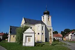 Church of All Saints | |
 Flag 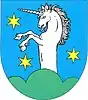 Coat of arms | |
 Jaroměřice Location in the Czech Republic | |
| Coordinates: 49°37′32″N 16°45′7″E / 49.62556°N 16.75194°E | |
| Country | |
| Region | Pardubice |
| District | Svitavy |
| Founded | c. 1090 |
| Area | |
| • Total | 22.06 km2 (8.52 sq mi) |
| Elevation | 368 m (1,207 ft) |
| Population (2023-01-01)[1] | |
| • Total | 1,172 |
| • Density | 53/km2 (140/sq mi) |
| Time zone | UTC+1 (CET) |
| • Summer (DST) | UTC+2 (CEST) |
| Postal codes | 569 43, 569 44 |
| Website | www |
Jaroměřice is a municipality and village in Svitavy District in the Pardubice Region of the Czech Republic. It has about 1,200 inhabitants.
Jaroměřice lies approximately 26 kilometres (16 mi) south-east of Svitavy, 85 km (53 mi) south-east of Pardubice, and 176 km (109 mi) east of Prague.
Administrative parts
The village of Nový Dvůr is an administrative part of Jaroměřice.
Gallery
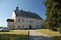 Jaroměřice Castle
 Church of the Exaltation of the Holy Cross on the Calvary
References
Wikimedia Commons has media related to Jaroměřice.
This article is issued from Wikipedia. The text is licensed under Creative Commons - Attribution - Sharealike. Additional terms may apply for the media files.