| Jejora | |
|---|---|
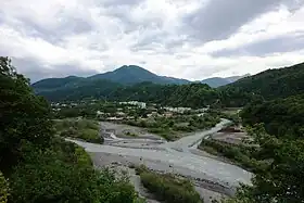
 Jejora (right) at the confluence with the Rioni. Oni town is in the background. | |
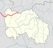
 Jejora with Jochiara on the map of South Ossetia | |
| Native name | |
| Location | |
| Country | Georgia |
| Physical characteristics | |
| Mouth | Rioni |
• location | Oni, Georgia |
• coordinates | 42°34′30″N 43°25′31″E / 42.57500°N 43.42528°E |
| Length | 45 km (28 mi) |
| Basin size | 438 km2 (169 sq mi) |
| Basin features | |
| Progression | Rioni→ Black Sea |
The Jejora (Georgian: ჯეჯორა) is a river in Racha region of Georgia.[1] It is 45 km (28 mi) long, and has a drainage basin of 438 km2 (169 sq mi).[2] It is a left tributary of the Rioni. It originates in South Ossetia in the Dvaleti section of the main watershed of the Greater Caucasus, 2975 m above sea level and flows in a western direction. South of the river valley rises the mountains of the Racha Range. It joins the Rioni at Oni town.[3]
References
Wikimedia Commons has media related to Jejora river.
- ↑ Jejora, Racha-Lechkhumi and Kvemo Svaneti, Georgia Mindat.org
- ↑ (in Russian) Апхазава, Илья Соломонович; Грузинская советская энциклопедия. Том 11, Страница 557, Тбилиси, Год 1987.
- ↑ (in Georgian) River Jejora Travel in Georgia
This article is issued from Wikipedia. The text is licensed under Creative Commons - Attribution - Sharealike. Additional terms may apply for the media files.