Jeti-Ögüz
Жети-Өгүз району | |
|---|---|
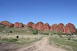 The Jeti-Ögüz rock formation from which Jeti-Ögüz District gets its name, and near-by resort. | |
 Flag  Coat of arms | |
 | |
| Coordinates: 42°20′N 78°00′E / 42.333°N 78.000°E | |
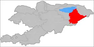
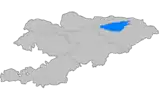
| Country | Kyrgyzstan |
| Region | Issyk-Kul |
| Area | |
| • Total | 14,499 km2 (5,598 sq mi) |
| Population (2023)[1] | |
| • Total | 99,690 |
| • Density | 6.9/km2 (18/sq mi) |
| Time zone | UTC+6 |
Jeti-Ögüz (Kyrgyz: Жети-Өгүз [dʒeti œɣýz], seven bulls) is a district of Issyk-Kul Region in north-eastern Kyrgyzstan. Its seat lies at Kyzyl-Suu.[2] Its area is 14,499 square kilometres (5,598 sq mi),[3] and its resident population was 93,392 in 2021.[1] It comprises much of the eastern end of the Terskey Ala-Too Range.
Geography
The Terskey Alatau, Ak-Shiyrak Range, Borkoldoy Too, Jetim Bel Range, and Kakshaal Too spread across the Jeti-Ögüz District. Major valleys include Issyk-Kul Valley, Upper Naryn Valley, Ak-Shiyrak Valley, and so on. The district contains deposits of ores of tin, tungsten, copper and other metals. Among its large rivers are the Naryn, Saryjaz, Barskoon, Jeti-Ögüz, etc.
 Broken Heart Rock
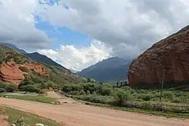 Near the end of Juuku Gorge
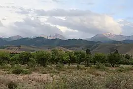 The Teskey Ala-Too range as seen from the beach at Ak Terek
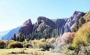
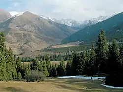 The mountains a bit south of Jeti Ögüz rock formation
Population
| Year | Pop. | ±% p.a. |
|---|---|---|
| 1970 | 57,804 | — |
| 1979 | 61,121 | +0.62% |
| 1989 | 67,597 | +1.01% |
| 1999 | 74,414 | +0.97% |
| 2009 | 82,085 | +0.99% |
| 2021 | 93,392 | +1.08% |
| Note: resident population; Sources:[3][1] | ||
Rural communities and settlements
In total, Jeti-Ögüz District includes 47[2] villages located in 13 rural communities (ayyl aymagy). Each rural community may consist of one or several villages. The rural communities and settlements in the Jeti-Ögüz District are:[2]
- Ak-Döbö (seat: Munduz; incl. Ak-Döbö, Ang-Östön and Tilekmat)
- Ak-Shyyrak (seat: Ak-Shyyrak; incl. Kulttsentr and Yshtyk)
- Aldashev (seat: Saruu; incl. Juuku and Ysyk-Köl)
- Barskoon (seat: Barskoon; incl. Karakol, Kara-Say and Söök)
- Darkan (seat: Darkan)
- Jargylchak (seat: Ak-Terek; incl. Jengish, Kichi-Jargylchak and Chong-Jargylchak)
- Jeti-Ögüz (seat: Jeti-Ögüz; incl. Ak-Kochkor, Jele-Döbö, Jeti-Ögüz resort, Kabak, Taldy-Bulak and Chyrak)
- Kyzyl-Suu (seat: Kyzyl-Suu; incl. Jalgyz-Örük, Kaynar and Pokrovka Pristany)
- Lipenka (seat: Lipenka; incl. Bogatyrovka, Zelenyy Gay and Ichke-Bulung)
- Orgochor (seat: Orgochor; incl. Boz-Beshik, Kurgak-Ayryk and Podgornoye)
- Svetlaya Polyana (seat: Svetlaya Polyana; incl. Chong-Kyzyl-Suu)
- Tamga (seat: Tamga; incl. Tosor)
- Yrdyk (seat: Alkym; incl. Jon-Bulak, Komsomolskoye, Konkino and Yrdyk)
Jalgyz-
Oruk
Abbreviations: A - An-Osten, J - Jele-Debe
References
- 1 2 3 "Population of regions, districts, towns, urban-type settlements, rural communities and villages of Kyrgyz Republic" (XLS) (in Russian). National Statistics Committee of the Kyrgyz Republic. 2021. Archived from the original on 10 November 2021.
- 1 2 3 "Classification system of territorial units of the Kyrgyz Republic" (in Kyrgyz). National Statistics Committee of the Kyrgyz Republic. May 2021. pp. 10–12.
- 1 2 "2009 population and housing census of the Kyrgyz Republic: Issyk-Kul Region" (PDF) (in Russian). National Statistics Committee of the Kyrgyz Republic. 2010. pp. 11, 16.
| North Kyrgyzstan |
|  Raions of Kyrgyzstan | ||||||||||
|---|---|---|---|---|---|---|---|---|---|---|---|---|
| South Kyrgyzstan |
| |||||||||||
Places adjacent to Jeti-Ögüz District | |
|---|---|