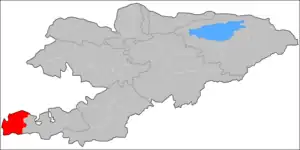
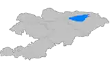
Leylek
Лейлек району | |
|---|---|
 | |
 Coat of arms | |
 | |
| Country | Kyrgyzstan |
| Region | Batken |
| Capital | Razzaqov |
| Area | |
| • Total | 4,653 km2 (1,797 sq mi) |
| Population (2021) | |
| • Total | 146,020 |
| • Density | 31/km2 (81/sq mi) |
| Time zone | UTC+6 |
Leylek (Kyrgyz: Лейлек району, romanized: Leylek rayonu) is a district of Batken Region in south-western Kyrgyzstan.[1] It borders with Batken District in the east, and Tajikistan in the south, west, and north. Its area is 4,653 square kilometres (1,797 sq mi),[2] and its resident population was 146,020 in 2021.[3] The administrative seat lies at Razzaqov.[1]
Geography
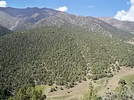
Leylek District is located between the northern slopes of the Turkestan Range and the Ferghana Valley. It contains the lowest point of Kyrgyzstan: 401 meters above sea level.[4]
Population
| Year | Pop. | ±% p.a. |
|---|---|---|
| 1970 | 40,280 | — |
| 1979 | 51,615 | +2.79% |
| 1989 | 74,531 | +3.74% |
| 1999 | 100,285 | +3.01% |
| 2009 | 116,861 | +1.54% |
| 2021 | 146,020 | +1.87% |
| Note: resident population; Sources:[2][3] | ||
Towns, rural communities and villages
In total, Leylek District includes 1 town and 47 villages in 1 town and 9 rural communities (ayyl aymagy).[1] The rural communities and settlements in the Leylek District are:[5]
- town of district significance Razzaqov (including 6 villages: Golbo, Samat, Chimgen, Taylan, Ak-Bosogo and Ak-Bulak)
- Ak-Suu (seat: Ak-Suu; and also villages Alga, Jengish, Suu-Bashy and Jezken)
- Beshkent (seat: Beshkent; incl. Karl Marks, Kayragach, SSSRdin 50 jyldygy and Eski-Oochu)
- Jangy-Jer (seat: Tsentralnoye; incl. Arka and Dostuk)
- Katrang (seat: Katrang; incl. Jangy-Turmush and Özgörüsh)
- Kulundu (seat: Kulundu; incl. Bulak-Bashy, Internatsional'noye, Kommunizm, Lenin and Maksat)
- Leylek (seat: Korgon; incl. Kara-Suu, Leylek, Chuyanchy and Ak-Terek)
- Muras (seat: Muras; incl. Uch-Bulak, Jetty-Tash and Kerege-Tash)
- Sumbula (seat: Andarak; incl. Iskra, Kök-Tash and Sary-Dobo)
- Toguz-Bulak (seat: Toguz-Bulak; and also villages Ay-Kol, Kara-Bulak, Madaniyat, Kyrgyzstandyn 50 jyldygy and Chapaev)
Note: Sülüktü is a town of regional significance of Batken Region, and is not part of the Leylek District.
SSSRdin
50 jyldygy
Suu
50 jyldygy
Aykol
References
- 1 2 3 "Classification system of territorial units of the Kyrgyz Republic" (in Kyrgyz). National Statistics Committee of the Kyrgyz Republic. May 2021. pp. 40–42.
- 1 2 "2009 population and housing census of the Kyrgyz Republic: Batken Region" (PDF) (in Russian). National Statistics Committee of the Kyrgyz Republic. 2010. pp. 14, 17.
- 1 2 "Population of regions, districts, towns, urban-type settlements, rural communities and villages of Kyrgyz Republic" (XLS) (in Russian). National Statistics Committee of the Kyrgyz Republic. 2021. Archived from the original on 10 November 2021.
- ↑ "Лейлек району" [Leylek District] (PDF). Кыргызстандын Географиясы [Geography of Kyrgyzstan] (in Kyrgyz). Bishkek. 2004. p. 461.
{{cite encyclopedia}}: CS1 maint: location missing publisher (link) - ↑ List of Rural Communities of Kyrgyzstan Archived 2010-02-09 at the Wayback Machine
| North Kyrgyzstan |
|  Raions of Kyrgyzstan | ||||||||||
|---|---|---|---|---|---|---|---|---|---|---|---|---|
| South Kyrgyzstan |
| |||||||||||