Jiliya | |
|---|---|
village | |
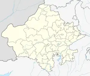
 Jiliya Location in Rajasthan, India  Jiliya Jiliya (India) | |
| Coordinates: 27°08′N 74°31′E / 27.14°N 74.51°E | |
| Country | |
| State | Rajasthan |
| District | Nagaur |
| Elevation | 486 m (1,594 ft) |
| Population (2001) | |
| • Total | 7,000 |
| Languages | |
| • Official | Hindi |
| Time zone | UTC+5:30 (IST) |
| PIN | 341508 |
| Telephone code | 01586 |
| ISO 3166 code | RJ-IN |
| Website | uq |
Jiliya is a place in Nagaur District of Rajasthan, India. It was a Princely Thikana in British India. It is developing as a tourist spot to explore the natural environment of Rajasthan. The majority of the population is involved in agricultural and trade activities. NGOs such as Sankalp Volunteer Society are active in this region of Rajasthan and foreigners participate in the "Jiliya Project" which is one of the five projects of this NGO in India.
History

During British rule in India Abhaypura or Jiliya was a Princely Thikana of the Princely State of Jodhpur. Princely State Abhaypura was half of Maroth state[1] and was founded around 1683 AD (1740 BS) by Maharaja Bijay Singh, third son of Maharaja Raghunath Singh Mertia Rathore of Maroth.[2] In 1820 AD it accepted nominal allegiance of Jodhpur State.[3] It had 40 villages of Maroth;[4] later, after a treaty it became a Thikana of Marwar and is now called as Thikana Jiliya and has 14 villages, as the rest of the villages were given as appanages or jagirs to younger brothers.[5][6]
As per Indira Gandhi National Centre for the Arts, the paintings of the Man Mandir Temple of Maroth, Rajasthan best depict the art form of the 17th Century Rajputana.[7]
Title
The title of the rulers "Tazim Naresh Maharaja Shri" (Great Hon'ble King) is derived from the Urdu word Tazeem (Tazim) meaning 'respect' or 'honour', which describes their special position as a Dual Tazimi Thikana in the Princely State of Jodhpur whom the Jodhpur Maharaja receives in Darbar by rising from throne, taking steps, and hugging, and are exempted from appearance in Courts of Law in Civil Cases; and Naresh meaning "King" or "Maharaja" or "Raja".[8][9]
A volunteer program known as the Jiliya Project, run by the Sankalp Volunteer Society NGO, is active in the region as Nagaur is one of the economically underdeveloped districts of the state. Being a desert area, it also suffers from lack of water which makes the situation even worse for agricultural activities.[10]
Medical and infrastructure facilities
There are few government and private medical aid centers, hospitals, dispensaries in Jiliya, and nearby Hospitals are at Kuchaman City.
General information
- Religion: 99% of population are Hindus
- Geographical Location: 13 km from Kuchaman City
- Temperature: Max. 44 °C in June, Min. 1 °C in January
- Monsoon Season: June to July
- Annual Rainfall: 412 mm
- Census Code: 01892800
References
- ↑ Rajawat, Daulat Singh (1991). "Glimpses of Rajasthan: Off the Beaten Track".
- ↑ "वीर श्रेष्ठ रघुनाथ सिंह मेडतिया , मारोठ-1".
- ↑ http://freepages.genealogy.rootsweb.ancestry.com/~princelystates/states/m/maroth.html
- ↑ (India), Rajasthan (1962). "Rajasthan [district Gazetteers].: Nagaur".
- ↑ "JILIYA". Archived from the original on 24 December 2013. Retrieved 17 July 2012.
- ↑ "Archived copy". Archived from the original on 29 September 2015. Retrieved 24 July 2014.
{{cite web}}: CS1 maint: archived copy as title (link) - ↑ "Rajasthani Kala: Itihas Ka Poorak Sadhan".
- ↑ Bhaskar News, 28 March 2012, "Meeting regarding Maharaja Raghunath Singh Anniversary" (महाराजा रघुनाथ सिंह), News Inbox, http://www.bhaskar.com/article/RAJ-OTH-1924734-3025514.html Archived 28 July 2014 at the Wayback Machine
- ↑ "Archived copy". Archived from the original on 29 September 2015. Retrieved 24 July 2014.
{{cite web}}: CS1 maint: archived copy as title (link) - ↑ "Home". volunteersindia.org.
- ↑ http://nrhmrajasthan.nic.in/CHC%20List/PHC%20List/Nagaur.pdf
- ↑ "Archived copy" (PDF). Archived from the original (PDF) on 17 July 2011. Retrieved 27 March 2010.
{{cite web}}: CS1 maint: archived copy as title (link)