Johns Township, Appanoose County | |
|---|---|
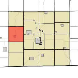 | |
| Coordinates: 40°46′07″N 093°02′24″W / 40.76861°N 93.04000°W | |
| Country | |
| State | |
| County | Appanoose |
| Area | |
| • Total | 36.25 sq mi (93.88 km2) |
| • Land | 36.20 sq mi (93.75 km2) |
| • Water | 0.05 sq mi (0.13 km2) |
| Elevation | 1,030 ft (314 m) |
| Population (2010) | |
| • Total | 287 |
| • Density | 8/sq mi (3.1/km2) |
| FIPS code | 19-92271[2] |
| GNIS feature ID | 0468152 |
Johns Township is one of eighteen townships in Appanoose County, Iowa, United States. As of the 2010 census, its population was 287.[3]
The township's name was selected due to an unusually large percentage of early settlers sharing the name John.[4]
Geography
Johns Township covers an area of 36.25 square miles (93.88 km2) and contains one incorporated settlement, Plano. According to the USGS, it contains five cemeteries: Concord, Crossroads, Garfield, Lyons and Philadelphia.
References
- ↑ "US Board on Geographic Names". United States Geological Survey. October 25, 2007. Retrieved January 31, 2008.
- ↑ "U.S. Census website". United States Census Bureau. Retrieved January 31, 2008.
- ↑ "Geographic Identifiers: 2010 Demographic Profile Data (G001): Johns township, Appanoose County, Iowa". U.S. Census Bureau, American Factfinder. Archived from the original on February 12, 2020. Retrieved May 9, 2013.
- ↑ Appanoose County Historical Society (2013). Appanoose County. Arcadia Publishing. p. 73. ISBN 978-0-7385-9899-4.
External links
Municipalities and communities of Appanoose County, Iowa, United States | ||
|---|---|---|
| Cities | Map of Iowa highlighting Appanoose County | |
| Townships | ||
| Unincorporated communities | ||
This article is issued from Wikipedia. The text is licensed under Creative Commons - Attribution - Sharealike. Additional terms may apply for the media files.