| Kılıçkaya Dam | |
|---|---|
 | |
| Official name | Kılıçkaya Barajı (Turkish) |
| Country | Turkey |
| Location | Kelkit River, Sivas Province[1] |
| Coordinates | 40°14′N 38°11′E / 40.233°N 38.183°E |
| Purpose | Multi-purpose |
| Construction began | 1980 |
| Opening date | 1989[2] or 1990[1][3] |
| Operator(s) | Elektrik Uretim AS[3] |
| Dam and spillways | |
| Type of dam | Rock-fill dam |
| Height (thalweg) | 135 m[3] |
| Width (crest) | 405 m[3] |
| Dam volume | 6 900 000 m³ |
| Spillway volumetric flow rate | 7,800 m³/s |
| Reservoir | |
| Total capacity | 1400 billion m³[1] |
| Surface area | 64 km²[1] |
| Spillway volumetric flow rate | 139 m³/s |
| Installed capacity | 124 MW[1] |
| Annual generation | 332 000 mwh/year[1] |
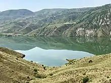
Kılıçkaya Dam is a dam located 25 km north of town of Suşehri 158 km northeast of Sivas city in center east of Turkey and located on the Kelkit, a tributary of the Yeşilırmak River which flows down along a large fault in the north east Anatolia than runs into the Black Sea.
Geology in the river basin, where many landslides can be observed, is of sedimentary formation.
References
- 1 2 3 4 5 6 "Devlet Su İşleri Genel Müdürlüğü: Kılıçkaya Barajı ve Hidroelektrik Santrali" (in Turkish). General Directorate of State Hydraulic Works. Archived from the original on 25 February 2018.
- ↑ "KILICKAYA DAM (KILIÇKAYA BARAJI)". General Directorate of State Hydraulic Works. Archived from the original on 28 April 2002.
- 1 2 3 4 "Hydroelectric Power Plants in Northern Turkey". 28 November 2021. Archived from the original on 3 January 2013.
This article is issued from Wikipedia. The text is licensed under Creative Commons - Attribution - Sharealike. Additional terms may apply for the media files.