Kařez | |
|---|---|
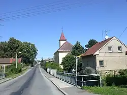 Church of Saint John of Nepomuk | |
 Flag  Coat of arms | |
 Kařez Location in the Czech Republic | |
| Coordinates: 49°49′28″N 13°46′54″E / 49.82444°N 13.78167°E | |
| Country | |
| Region | Plzeň |
| District | Rokycany |
| First mentioned | 1281 |
| Area | |
| • Total | 5.87 km2 (2.27 sq mi) |
| Elevation | 452 m (1,483 ft) |
| Population (2023-01-01)[1] | |
| • Total | 707 |
| • Density | 120/km2 (310/sq mi) |
| Time zone | UTC+1 (CET) |
| • Summer (DST) | UTC+2 (CEST) |
| Postal code | 338 08 |
| Website | www |
Kařez is a municipality and village in Rokycany District in the Plzeň Region of the Czech Republic. It has about 700 inhabitants.
Kařez lies approximately 17 kilometres (11 mi) north-east of Rokycany, 31 km (19 mi) east of Plzeň, and 55 km (34 mi) south-west of Prague.
Transport
Kařez is located on the railway lines Prague–Klatovy and Plzeň–Beroun.[2]
References
- ↑ "Population of Municipalities – 1 January 2023". Czech Statistical Office. 2023-05-23.
- ↑ "Detail stanice Kařez" (in Czech). České dráhy. Retrieved 2023-08-14.
Wikimedia Commons has media related to Kařez.
This article is issued from Wikipedia. The text is licensed under Creative Commons - Attribution - Sharealike. Additional terms may apply for the media files.