| Kalter Gang | |
|---|---|
 | |
| Location | |
| State | Lower Austria |
| Region | Industrieviertel |
| Physical characteristics | |
| Mouth | Schwechat |
• coordinates | 48°08′44″N 16°28′36″E / 48.14566°N 16.47665°E |
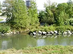
The Kalter Gang is a river in the Industrieviertel of Lower Austria, south of Vienna. It is a tributary of the Schwechat.
Geography
The Kalter Gang feeds on many groundwater sources in the area of the Mitterndorfer Senke, which are located in the municipal area of Ebreichsdorf right next to the Piesting. For this reason, the middle and upper reaches of the Piesting have often been erroneously referred to as the Kalter Gang.[1] Measurement results show, however, that the Kalter Gang is an independent body of water that is characterised by more even water temperatures (hence the name; lit. 'cold stream') and a higher magnesium sulphate content than the Piesting.[2]
Conservation
An approximately 1 km (0.6 mile) long section of the river near Pellendorf was rehabilitated in early 2019.[3]
See also
References
- ↑ Neilreich, August (1846). Flora von Wien. Vienna: Beck'sche Universitätsbuchhandlung. p. xvi.
- ↑ Küpper, Heinrich (1954). "Geologie und Grundwasservorkommen im südlichen Wiener Becken". Jahrbuch der Geologischen Bundesanstalt, no. 97. pp. 183, 189 (Piesting), p. 192 (Kalter Gang).
- ↑ "Kalter Gang in Pellendorf wird geräumt". MeinBezirk.at. 14 February 2019. Retrieved 15 October 2022.