Mukim Pekan Tutong | |
|---|---|
 | |
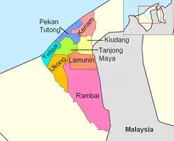 Pekan Tutong is in dark blue. | |
| Coordinates: 4°48′N 114°39′E / 4.8°N 114.65°E | |
| Country | Brunei |
| District | Tutong |
| Population (2016)[1] | |
| • Total | 10,551 |
| Time zone | UTC+8 (BNT) |
| Postcode | TAxx41 |
Mukim Pekan Tutong is a mukim in Tutong District, Brunei. The population was 10,551 in 2016.[1] It encompasses Pekan Tutong, the district's sole town and administrative centre.
Geography
The mukim is located in the north-west of Tutong District, bordering the South China Sea to the north-west, Mukim Keriam to the east, Mukim Kiudang to the south-east, Mukim Tanjong Maya to the south and Mukim Telisai to the south-west.
The Tutong River runs its course through the mukim and flows out into South China Sea. There are a few islands along the river, among them the islets of Setawat (Pulau Setawat) and Bakuku (Pulau Bakuku).
Demographics
As of 2016 census,[1] the population was 10,551 with 51.2% males and 48.8% females. The mukim had 1,882 households occupying 1,871 dwellings. The mukim is predominantly urban; 85.9% lived in urban areas in contrast to 14.1% in rural areas.
Villages
As of 2016, the mukim comprised the following census villages:[1]
| Village | Population (2016) |
|---|---|
| Bukit Bendera | 1,067 |
| Kampong Kandang | 305 |
| Kampong Kuala Tutong | 295 |
| Kampong Panchor Dulit | 541 |
| Kampong Panchor Papan | 483 |
| Kampong Penabai | 888 |
| Kampong Penanjong | 2,065 |
| Kampong Petani | 997 |
| Kampong Sengkarai | 1,989 |
| Kampong Serambangun | 357 |
| Kampong Tanah Burok | 465 |
| Tutong Camp | 1,099 |
| Total | 10,551 |
The municipal area of Pekan Tutong encompasses parts of Bukit Bendera and Kampong Petani.
References
- 1 2 3 4 "Population and Housing Census Update Final Report 2016" (PDF). www.deps.gov.bn. Statistics Department. December 2018. Retrieved 27 June 2021.