Lugu
Kampung Lugu | |
|---|---|
| Kampong Lugu | |
 RPN Kampong Lugu | |
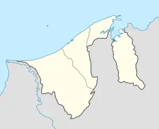 Location in Brunei | |
| Coordinates: 4°52′33″N 114°48′12″E / 4.8758°N 114.8032°E | |
| Country | Brunei |
| District | Brunei-Muara |
| Mukim | Sengkurong |
| Population (2021)[1] | |
| • Total | 5,795 |
| Demonym | Lugunese |
| Time zone | UTC+8 (BNT) |
| Postcode | BG2921 |
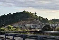
Kampong Lugu is a village in the west of Brunei-Muara District. It comprises the original village settlement and the public housing estate RPN Kampong Lugu. The population was 5,795 in 2021.[2] It is one of the villages within Mukim Sengkurong.
Geography
Kampong Lugu is located in the westernmost part of Brunei-Muara District and thus borders Tutong District. It neighbours Kampong Katimahar to the south.[3] Lugu Lake is an artificial freshwater lagoon which sits below the RPN Kampong Lugu and along the Muara–Tutong Highway.[4]
See also
References
- ↑
- ↑ "Population and Housing Census Update Final Report 2016" (PDF). www.deps.gov.bn. Department of Statistics. December 2018. Retrieved 20 July 2021.
- ↑ "Geoportal - Survey Department". survey.gov.bn. Retrieved 1 July 2018.
- ↑ activ8bn. "Lugu Lake (along the Jerudong-Tutong highway)". Brunei Tourism. Retrieved 16 May 2022.
{{cite web}}: CS1 maint: numeric names: authors list (link)
This article is issued from Wikipedia. The text is licensed under Creative Commons - Attribution - Sharealike. Additional terms may apply for the media files.