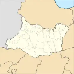
Kanor | |
|---|---|
 Kanor Location in Bojonegoro Regency | |
| Coordinates: 7°06′42″S 112°02′09″E / 7.1116°S 112.0357°E | |
| Country | |
| Province | East Java |
| Regency | Bojonegoro |
| Government | |
| • Camat | Subiyono, SH, MSi |
| Area | |
| • Total | 59.78 km2 (23.08 sq mi) |
| Population (2020 Census)[1] | |
| • Total | 59,637 |
| • Density | 1,000/km2 (2,600/sq mi) |
| Time zone | UTC+7 Western Indonesian Time |
| Postcode | 62193 |
| Area code | +62 353 |
| Website | http://kanor.bojonegorokab.go.id |
Kanor (Indonesian: Kecamatan Kanor) is a district of Bojonegoro Regency, East Java, Indonesia.
Administration
Kanor consists of 25 administrative villages (Indonesian: kelurahan, desa).
|
|
|
References
- ↑ Badan Pusat Statistik, Jakarta, 2021.
This article is issued from Wikipedia. The text is licensed under Creative Commons - Attribution - Sharealike. Additional terms may apply for the media files.