| Kanuti River | |
|---|---|
 | |
 Location of the mouth of the Kanuti River in Alaska | |
| Location | |
| Country | United States |
| State | Alaska |
| Census Area | Yukon–Koyukuk |
| Physical characteristics | |
| Source | near western border of the Yukon Flats National Wildlife Refuge |
| • location | east of the Dalton Highway and slightly south of the Arctic Circle |
| • coordinates | 66°31′12″N 150°04′22″W / 66.52000°N 150.07278°W[1] |
| • elevation | 3,312 ft (1,009 m)[2] |
| Mouth | Koyukuk River[1] |
• location | Kanuti National Wildlife Refuge, 13 miles (21 km) southwest of Allakaket |
• coordinates | 66°26′48″N 152°59′51″W / 66.44667°N 152.99750°W[1] |
• elevation | 381 ft (116 m)[1] |
| Length | 175 mi (282 km)[3] |
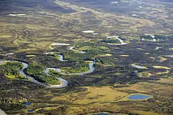
The Kanuti (Kkʼoonootnoʼ in Koyukon[4]) is a 175-mile (282 km) tributary of the Koyukuk River in the U.S. state of Alaska.[3] The river begins near the Arctic Circle and flows generally west, passing under the Dalton Highway near Caribou Mountain.[5] After continuing through a relatively flat basin, it enters a 1,200-foot (370 m) deep canyon before meeting the larger river near Allakaket.[6] The Kanuti National Wildlife Refuge covers a large part of the river basin.[5]
See also
References
- 1 2 3 4 "Kanuti River". Geographic Names Information System. United States Geological Survey. March 31, 1981. Retrieved October 22, 2013.
- ↑ Derived by entering source coordinates in Google Earth.
- 1 2 Orth, Donald J.; United States Geological Survey (1971) [1967]. Dictionary of Alaska Place Names: Geological Survey Professional Paper 567 (PDF). University of Alaska Fairbanks. United States Government Printing Office. p. 495. Archived from the original (PDF) on October 17, 2013. Retrieved October 22, 2013.
- ↑ Chapter 5.7: Athabaskan Place Names for Rivers in Alaska. Bethel, Alaska: Lower Kuskokwim School District. Archived from the original on October 23, 2013. Retrieved October 22, 2013.
{{cite book}}:|work=ignored (help) - 1 2 Alaska Atlas & Gazetteer (7th ed.). Yarmouth, Maine: DeLorme. 2010. p. 136. ISBN 978-0-89933-289-5.
- ↑ Maddren, Alfred Geddes (1913). The Koyukuk–Chandalar Region, Alaska (United States Geological Survey Bulletin 532). Washington, D.C.: U.S. Government Printing Office. p. 23. Retrieved January 6, 2013.
This article is issued from Wikipedia. The text is licensed under Creative Commons - Attribution - Sharealike. Additional terms may apply for the media files.