Kattappana | |
|---|---|
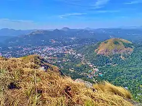
From top, left to right: Kattappana from a nearby mountain, Kattappana new private bus stand , Housing Board Shopping Complex, St. George Forane Church and Kattappana Municipality Office. | |
|
Logo | |
 Kattappana Location in Kerala, India  Kattappana Kattappana (India) | |
| Coordinates: 09°45′15″N 77°06′57″E / 9.75417°N 77.11583°E | |
| Country | |
| State | |
| District | Idukki |
| Government | |
| • Type | Municipality |
| • Body | Kattappana Municipality |
| • Municipal Chairperson | Shiny Sunny Cherian |
| Area | |
| • Total | 61.32 km2 (23.68 sq mi) |
| Elevation | 900 m (3,000 ft) |
| Population (2011) | |
| • Total | 42,646 |
| • Density | 700/km2 (1,800/sq mi) |
| Languages | |
| • Official | Malayalam, English |
| Time zone | UTC+5:30 (IST) |
| PIN | 685508, 685515 |
| Telephone code | 04868 |
| Vehicle registration | KL-06 (Idukki) |
| Literacy | 95.25% |
| Lok Sabha constituency | Idukki |
| Sex ratio | 1016 ♂/♀ |
| Website | Kattappana Municipality |
Kattappana stands as a vibrant municipal town nestled within the lush embrace of the Sahyadri (or Western Ghats) in Kerala state, India. Positioned at an elevation of approximately 2,788.71–2,952.76 feet (850.00–900.00 m) above sea level, it proudly serves as the principal urban hub in the high ranges of Idukki district. This town holds the distinction of being the second to attain municipal status in the Idukki District. Renowned for its bustling commerce, Kattappana thrives on agriculture and spice production, shaping its identity as a significant commercial center.
Municipal administration
Previously, Kattappana was included in the Udumbanchola tehsil (taluk) of Idukki district and was later included in the newly formed Idukki tehsil (taluk). It was officially declared as municipality by the state government on 1 November 2015. It became the second municipality in the district, while Thodupuzha became the first. The first municipal chairman was Mr. Johny Kulampallil.
It is one of the more important commercial centre in the high ranges and was on a fast track in terms of development and infrastructure building. However, it was the development of the Kottayam–Kattappana road and the Puliyanmala–Thodupuzha State highway that turned the town into a commercial centre. It was the agriculture sector that played a pivotal role in economically uplifting the town.
The Union Minister for Urban Development, Housing & Urban Poverty Alleviation and Information & Broadcasting, Shri M. Venkaiah Naidu presented the Swachhata Certificate to then Chairman of Kattappana Municipality Shri Johny Kulampally on becoming the Open Defecation Free Municipality in Kerala, in Kochi on October 18, 2016.
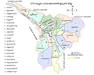
For administrative convenience, the municipality is divided into 34 wards.
| Ward No. | Ward Name | Ward No. | Ward Name |
|---|---|---|---|
| 1 | Vazhavara | 18 | Kunthalampara North |
| 2 | Nirmala city | 19 | Kunthalampara South |
| 3 | Society | 20 | Pallikavala |
| 4 | Konginippadavu | 21 | Erupathekkar |
| 5 | Vellayamkudy | 22 | Ambalakkavala |
| 6 | Vettikkuzhakavala | 23 | Mettukkuzhi |
| 7 | Nathukallu | 24 | Vallakkadavu |
| 8 | Kallukunnu | 25 | Kadamakkuzhy |
| 9 | Pezhumkavala | 26 | Nariampara |
| 10 | Valiyapara | 27 | Thovarayar |
| 11 | Kochuthovala North | 28 | I T I Kunnu |
| 12 | Kochuthovala | 29 | Valiyakandam |
| 13 | Anakuthy | 30 | Govt. College |
| 14 | Parakkadavu | 31 | Suvarnagiri |
| 15 | Puliyanmala | 32 | Kalyanathandu |
| 16 | Ambalappara | 33 | Mulakaramedu |
| 17 | Kattappana | 34 | Kounthi |
Demographics
As of 2011 Census, Kattappana had a population of 42,646, with 21,159 males and 21,487 females. Kattappana has an area of 61.32 km2 (23.68 sq mi) with 10,419 families residing in it. Kattappana had an average literacy of 95.25% higher than the state average of 94%.[1]
People migrated to this place mainly during the 1950s from Central Travancore. The migrations were majorly from Palai, Chenganassery and Kanjirapally taluks of Kottayam district and Pathanamthitta. Descendants of earlier inhabitants, the tribals of the forest, can still be seen. The Mannan tribe is now concentrated around Kovilmala, near Kanchiyar.[2]
Agriculture
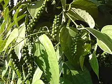
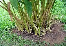
Kattappana is the center for spices trade and the primary producer of cardamom[3] and black pepper. The main occupation of people of Kattappana is agriculture. A specific type Njallani high yielding variety of cardamom, was developed in Kattappana. It is also the centre of production and marketing of coffee, cocoa and ginger. There are also several reputed tea plantations (Tata Tea, A V Thomas & Co, Malayalam Plantations, Kannan Devan etc.) in adjoining areas of the district.
Spices Board (erstwhile Cardamom Board under Government of India) has an office in Kattappana. A Spices Park is established at Puttadi near Kattappana. Cardamom Research Institute is situated at Pampadumpara.
Njallani high yielding variety of cardamom was developed by Sebastian Joseph Njallani from Kattappana.[4]
Climate
The climate of Kattappana falls under the Köppen climate classification. The place normally experiences a moderate climate. The humidity rises from the month of March to April and mid May. The average annual temperature here is 23 °C. The months of June, July, August and October receives significant amount of rainfall. November and December are the coldest months in the year.
| Climate data for Kattappana, Kerala | |||||||||||||
|---|---|---|---|---|---|---|---|---|---|---|---|---|---|
| Month | Jan | Feb | Mar | Apr | May | Jun | Jul | Aug | Sep | Oct | Nov | Dec | Year |
| Mean daily maximum °C (°F) | 26.1 (79.0) |
27.4 (81.3) |
29.1 (84.4) |
29.3 (84.7) |
29.2 (84.6) |
27.2 (81.0) |
26.1 (79.0) |
26.5 (79.7) |
26.8 (80.2) |
26.2 (79.2) |
25.5 (77.9) |
25.5 (77.9) |
27.1 (80.7) |
| Mean daily minimum °C (°F) | 16.8 (62.2) |
17.5 (63.5) |
19.0 (66.2) |
20.2 (68.4) |
20.8 (69.4) |
20.1 (68.2) |
19.6 (67.3) |
19.6 (67.3) |
19.3 (66.7) |
19.1 (66.4) |
18.5 (65.3) |
17.2 (63.0) |
19.0 (66.2) |
| Average precipitation mm (inches) | 22 (0.9) |
30 (1.2) |
52 (2.0) |
116 (4.6) |
163 (6.4) |
307 (12.1) |
396 (15.6) |
246 (9.7) |
163 (6.4) |
252 (9.9) |
176 (6.9) |
75 (3.0) |
1,998 (78.7) |
| Source: Climate-Data.org[5] | |||||||||||||
Notable people
- Shaji Chen - Tamil, Malayalam writer and Tamil film actor
Healthcare
St. John's Hospital, managed by the Hospitaller Brothers of St. John of God, is a leading health institution in Kattappana.An institution named St. John College of Nursing is attached to the hospital[6]
Transportation
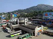
Kattappana has a well established road system to other districts as well as to nearby state Tamil Nadu. Recently one new National highway 185 announced to Idukki district, through Adimali-Cheruthoni-Kattappana-Kumily.
Distances to Nearby Towns
- Nedumkandam -
 - 18 km,
 - Kumily -
 - 26.8 km,
 - Kottayam -
 - 100.2 km,
 - Cumbum -
 - 31.2 km,
 - Palai -
 - 73.8 km,
 - Thodupuzha -
 - 85.8 km,
 - Changanassery -
 - 112 km,
 - Theni -
 - 68.8 km,
Major Roads Connecting Kattappana
References
- ↑ Kerala, Directorate of Census Operations. District Census Handbook, Idukki (PDF). Thiruvananthapuram: Directorateof Census Operations,Kerala. p. 58,59. Retrieved 14 July 2020.
- ↑ Mannan tribe
- ↑ Cardamom Cultivation
- ↑ "Tale of an Indigenous Farmer", Rediff.com
- ↑ "CLIMATE: KATTAPANA", Climate-Data.org. Web: .
- ↑ "St. John's Hospital website". Retrieved 17 August 2016.
