47°27′06″N 121°22′43″W / 47.451796°N 121.378716°W
| Kendall Katwalk | |
|---|---|
 Kendall Katwalk | |
| Length | Approx. 150 yards (140 m) |
| Location | Kittitas County, Washington |
| Trailheads | Snoqualmie Pass |
| Use | Hiking, Trail running, Backpacking |
| Highest point | 5,440 feet (1,660 m) |
| Lowest point | Base, 5,440 feet (1,660 m) |
| Difficulty | Moderate |
| Season | June to October |
| Hazards | Severe weather |
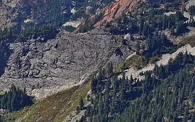
Kendall Katwalk seen from Alta Mountain
Kendall Katwalk is a 150 yard long narrow pathway blasted out of a steeply sloped granite rock face on the north ridge of Kendall Peak approximately 6 miles northeast of Snoqualmie Pass. It is a segment of Section J of Pacific Crest Trail and the construction was completed in 1979.[1] It is a popular destination for day hikers, trail runners, and backpackers
See also
- Mount_Katahdin's Knife Edge
References
- ↑ "Years of PCT Construction". Northwest Hiker's Net. Retrieved 31 May 2015.
External links
This article is issued from Wikipedia. The text is licensed under Creative Commons - Attribution - Sharealike. Additional terms may apply for the media files.