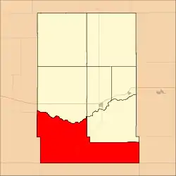
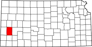
Kendall Township | |
|---|---|
 Location in Kearny County | |
| Coordinates: 37°48′50″N 101°26′19″W / 37.81389°N 101.43861°W | |
| Country | United States |
| State | Kansas |
| County | Kearny |
| Area | |
| • Total | 190.77 sq mi (494.09 km2) |
| • Land | 190.76 sq mi (494.07 km2) |
| • Water | 0.01 sq mi (0.02 km2) 0% |
| Elevation | 3,150 ft (960 m) |
| Population (2000) | |
| • Total | 157 |
| • Density | 0.8/sq mi (0.3/km2) |
| GNIS feature ID | 0471585 |
Kendall Township is a township in Kearny County, Kansas, United States. As of the 2000 census, its population was 157.[1]
Geography
Kendall Township covers an area of 190.77 square miles (494.09 square kilometers); of this, 0.01 square miles (0.02 square kilometers) or 0 percent is water. Lakes in this township include Clear Lake.
Adjacent townships
- Hartland Township (north)
- Lakin Township (northeast)
- Southside Township (northeast)
- Ivanhoe Township, Finney County (east)
- Dudley Township, Haskell County (southeast)
- Sherman Township, Grant County (south)
- Big Bow Township, Stanton County (southwest)
- Lamont Township, Hamilton County (west)
- Kendall Township, Hamilton County (northwest)
Major highways
Airports and landing strips
- Eveleigh Farms Airport
- Morgan Farms Airport
References
- ↑ "United States Census Bureau American FactFinder". Archived from the original on February 12, 2020. Retrieved June 24, 2008.
External links
This article is issued from Wikipedia. The text is licensed under Creative Commons - Attribution - Sharealike. Additional terms may apply for the media files.
