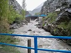
The Khojabakirgan (Kyrgyz: Кожо-Бакырган-Сай; Russian: Ходжабакирган) is a left tributary of the Syr Darya in Kyrgyzstan and Tajikistan (Central Asia).
The Khojabakirgan rises on the northern flank of the Turkestan Range in the Leilek District of the Batken Region of Kyrgyzstan. It initially flows in a predominantly northeasterly direction through the foothills. Later it turns north and northwest. When you reach the Ferghana Valley on the border with Tajikistan, it fans out into countless irrigation canals. Much of the water is channeled into the Great Ferghana Canal. The actual course of the river continues north-west past the cities of Chkalov and Khujand and ends on the southern bank of the Syr Darya.
Khojabakirgan is 130 km long. It drains an area of 1,740 km2. The mean discharge 45 km above the mouth is approximately 11 m³/s.[1]
Recently, a project viz. Improvement of irrigation management in the Aksu, Khojabakirgan (KB) and Samgar irrigation systems in the Syrdarya basin zone have been finished on 19 June 2023. The Organisation called HELVETAS Swiss Intercooperation has executed this job. This approach is one of the Sustainable Development Goals (SDGs) of the United Nations of Tajikistan.
References
- ↑ "Таблица 2 - Воды - Природа - О Кыргызстане - Добро пожаловать в Кыргызстан!". 2022-08-16. Archived from the original on 2022-08-16. Retrieved 2023-09-26.