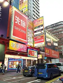
| King Wah Centre | |
|---|---|
瓊華中心 | |
 | |
| General information | |
| Location | Mong Kok Hong Kong |
| Address | 628 Nathan Road, Mongkok, Kowloon |
| Opening | 1955 |
The King Wah Centre (Chinese: 瓊華中心; Jyutping: king4 faa1 zung1 sam1), situated at the northeast corner of Shantung Street and Nathan Road, is a popular shopping centre in the Mong Kok area of Hong Kong. The 16-storey building features ten restaurant floors, three karaoke floors, along with 136 stores selling a variety of fashionable products.
History
King Wah Restaurant
In 1955, ‘The king of dim sum restaurants’ Tan Jienan (譚傑南), who was from Foshan and once operated Taotaoju (陶陶居) in Guangzhou, opened King Wah Restaurant.[1] [2] The floor area of the five storey building was approximately 40,000 square feet (3,700 m2) and used for banquets hosting more than 150 diners.[3] It was a landmark of Mong Kok at the time and served different segments of society on each of its five floors:
- 1/F was bakery with spittoon in the store that served grassroots
- 2/F was a Western restaurant
- 3/F was a Chinese tea housewith carpets (Chinese: 粵式茶樓);
- 4/F was a Chinese wine house (Chinese: 酒樓)with waiters serving customers with towels, and asked customers for tips;
- 5/F was a nightclub that served the upper class.
An unwritten tradition was that on horse racing days, gamblers would eat homemade Sachima at 20[4] to 30%[1] discount there. The commonly known name of Sachima (Chinese: 馬仔) is the pun of “horse” in Cantonese, thus gamblers believed that after they have eaten it, they would win at horse racing (“食完馬仔,贏馬仔” ).[1] During each year's Mid-Autumn Festival a large advertisement for moon cake would be displayed outside the restaurant.[1][5]
The restaurant closed in 1989.
King Wah Centre
The current building cost two hundred million Hong Kong dollars to build. It housed a Wing On department store in the 1990s. When that store closed the building was taken over by small independent shops selling popular clothing and accessories aimed primarily at teenage customers. The new shopping centre was colloquially referred to as "Red Spot" (Chinese: 紅點) as the building's sign used to feature a distinctive red spot, now covered up by other signage.[6]
A new tenant
In June 2013, all 130 original tenants moved out of King Wah Centre, which was taken over by the Sincere Department Store, one of the oldest local department stores in Hong Kong. Other bidders for the property included the American clothing brand Forever 21.[7] The rent will be in a monthly rate of HKD $6,000,000 and $200 per square feet with a rental period of 10 years. The Sincere shop in Grand Century Place (新世紀廣場) is currently undergoing refurbishment and is expected to be much smaller in size after the renovation, and Sincere found that King Wah Centre would a perfect location for Sincere to expand their business further in the same district.[8] Local citizens have criticized the loss of small businesses associated with this takeover.[9]
Floors
- B/F is the basement where there are photo sticker machines for people to take photos.[10]
- G/F is the ground floor which is leased out to Chow Sang Sang.[11]
- UG - 3/F is the Sincere department store.
- 5 - 16/F feature Japanese, Korean and Western restaurants.
References
- 1 2 3 4 "前身瓊華酒樓 重建只租不賣". Apple Daily. Retrieved 4 February 2013. (in Chinese)
- ↑ "果欄:旺角終變MK仔". Ming Pao. 12 February 2013. Archived from the original on 2 July 2013. Retrieved 6 April 2013.
- ↑ "瓊華大酒樓 versus 瓊天酒樓". Retrieved 20 May 2010. (in Chinese)
- ↑ "瓊華酒樓的薩琪瑪". RTHK. 13 April 2005. Archived from the original on 8 April 2014.
- ↑ "旺角瓊華酒樓舊照". Retrieved 14 December 2008. (in Chinese)
- ↑ 陳裕匡 (7 February 2013). 我與瓊華中心一起成長 [I grew up with King Wah Centre]. the House News. Archived from the original on June 4, 2014.
- ↑ Alleged monthly rent of 6 million dollars by Forever21 in Kingwah Centre, MingPaoDaily, 08 Feb 2013
- ↑ Apple Daily, “先施600萬搶租瓊華中心”, ‘ ‘ Apple Daily ‘ ‘, February 27, 2013
- ↑ "瓊華淪陷 趕絕小商戶". Sharp Daily. 4 February 2013.
- ↑ "商戶指南". Kingwah Centre.
- ↑ "Chow Sang Sang".
External links
 Media related to King Wah Centre at Wikimedia Commons