Kirjasalo
Кирьясало | |
|---|---|
Village | |
.jpg.webp) Inhabitants of Kirjasalo, 1920 | |
 Flag  Seal | |
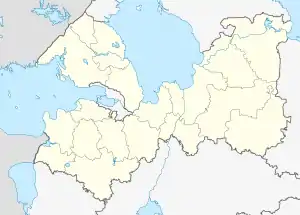
 Kirjasalo Location of Kirjasalo in Leningrad Oblast | |
| Coordinates: 60°26′23″N 30°05′52″E / 60.43972°N 30.09778°E | |
| Country | Russia |
| Federal District | Northwestern Federal District |
| Federal Subject | Leningrad Oblast |
| District | Priozersky District |
| Population | |
| • Total | 0 |
Kirjasalo (Russian: Кирьясало) is an abandoned village in Vsevolozhsky District of Leningrad Oblast, Russia. It was located between the Volchya and the Smorodinka rivers. Its population was largely composed of Ingrian Finns.
History
The village was first mentioned on a 17th-century map as Koriasilka.[1]
Kirjasalo has also been spelled as "Кирьясалы" (Kirjasaly) in older Russian maps, at least between 1885 and the 1920s.[2]
From 1919 to 1920, Kirjasalo served as the capital of the short-lived Republic of North-Ingria.
In the mid-1930s the population was for the most part repressed or deported to other areas of the Soviet Union.[3] During the Continuation War, the Finnish defensive VT-line passed through Kirjasalo.
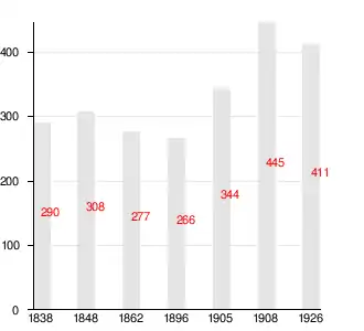
Demography

References
- ↑ "Исторические карты Всеволожского района | Фрагмент карты Нотебургского лена, начерченной в 1699 году с оригинала первой трети XVII века". vsevinfo.ru. Retrieved 2017-11-28.
- ↑ "Исторические карты Всеволожского района".
- ↑ Musajev, V.I. (2001). Polititšeskaja istorija Ingermanlandii v kontse XIX–XX veke. Kišinjov: Nestor-historia. p. 238. ISBN 9975-9606-4-2.
External links
![]() Media related to Kirjasalo at Wikimedia Commons
Media related to Kirjasalo at Wikimedia Commons