Kirwee | |
|---|---|
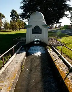
 De Renzie Brett memorial in Kirwee | |
| Coordinates: 43°30′S 172°13′E / 43.500°S 172.217°E | |
| Country | New Zealand |
| Region | Canterbury |
| Territorial authority | Selwyn District |
| Ward | Malvern |
| Community | Malvern |
| Electorates |
|
| Government | |
| • Territorial authority | Selwyn District Council |
| • Regional council | Environment Canterbury |
| • Mayor of Selwyn | Sam Broughton |
| • Selwyn MP | Nicola Grigg |
| • Te Tai Tonga MP | Tākuta Ferris |
| Area | |
| • Total | 3.68 km2 (1.42 sq mi) |
| Elevation | 157 m (515 ft) |
| Population (June 2023)[2] | |
| • Total | 1,180 |
| • Density | 320/km2 (830/sq mi) |
| Time zone | UTC+12 (New Zealand Standard Time) |
| • Summer (DST) | UTC+13 (New Zealand Daylight Time) |
| Postcode | 7571 |
| Area code | 03 |
Kirwee is a town located west of Christchurch in the Canterbury region of New Zealand's South Island. It was named after Karwi in India by retired British Army colonel De Renzie Brett.[3] Kirwee is also home to the South Island Agricultural Field Days, held biennially.[4][5]
History
In the early 1870s, Kirwee was intended to be the junction of two branch lines, one to Whitecliffs and the other to Sheffield and Springfield. The line from Kirwee to Darfield, intended to be the first portion of the Whitecliffs Branch, was built first and the decision was taken to establish the junction of the two branches in Darfield instead. The section of line from Kirwee to Darfield, as well as the branch to Sheffield and Springfield are now part of the Midland Line.
On 25 December 2019, the historic pub was gutted by a fire.[6] It was demolished in May 2020.[7]
Demographics
Kirwee is described by Statistics New Zealand as a rural settlement, and covers 3.68 km2 (1.42 sq mi).[1] It had an estimated population of 1,180 as of June 2023,[2] with a population density of 321 people per km2. It is part of the Kirwee statistical area.
| Year | Pop. | ±% p.a. |
|---|---|---|
| 2006 | 603 | — |
| 2013 | 768 | +3.52% |
| 2018 | 966 | +4.69% |
| Source: [8] | ||
Kirwee settlement had a population of 966 at the 2018 New Zealand census, an increase of 198 people (25.8%) since the 2013 census, and an increase of 363 people (60.2%) since the 2006 census. There were 354 households, comprising 495 males and 474 females, giving a sex ratio of 1.04 males per female, with 204 people (21.1%) aged under 15 years, 129 (13.4%) aged 15 to 29, 510 (52.8%) aged 30 to 64, and 135 (14.0%) aged 65 or older.
Ethnicities were 96.9% European/Pākehā, 4.0% Māori, 0.6% Pasifika, 1.2% Asian, and 2.8% other ethnicities. People may identify with more than one ethnicity.
Although some people chose not to answer the census's question about religious affiliation, 53.1% had no religion, 34.8% were Christian, 0.3% were Hindu and 1.9% had other religions.
Of those at least 15 years old, 153 (20.1%) people had a bachelor's or higher degree, and 126 (16.5%) people had no formal qualifications. 219 people (28.7%) earned over $70,000 compared to 17.2% nationally. The employment status of those at least 15 was that 450 (59.1%) people were employed full-time, 120 (15.7%) were part-time, and 18 (2.4%) were unemployed.[8]
Kirwee statistical area
Kirwee statistical area covers 97.19 km2 (37.53 sq mi).[1] It had an estimated population of 1,560 as of June 2023,[9] with a population density of 16.1 people per km2.
| Year | Pop. | ±% p.a. |
|---|---|---|
| 2006 | 918 | — |
| 2013 | 1,101 | +2.63% |
| 2018 | 1,275 | +2.98% |
| Source: [10] | ||


The statistical area had a population of 1,275 at the 2018 New Zealand census, an increase of 174 people (15.8%) since the 2013 census, and an increase of 357 people (38.9%) since the 2006 census. There were 474 households, comprising 648 males and 627 females, giving a sex ratio of 1.03 males per female. The median age was 42.2 years (compared with 37.4 years nationally), with 264 people (20.7%) aged under 15 years, 171 (13.4%) aged 15 to 29, 666 (52.2%) aged 30 to 64, and 171 (13.4%) aged 65 or older.
Ethnicities were 96.7% European/Pākehā, 4.9% Māori, 0.5% Pasifika, 1.4% Asian, and 2.1% other ethnicities. People may identify with more than one ethnicity.
The percentage of people born overseas was 16.0, compared with 27.1% nationally.
Although some people chose not to answer the census's question about religious affiliation, 52.9% had no religion, 36.0% were Christian, 0.2% were Hindu, 0.2% were Muslim and 2.1% had other religions.
Of those at least 15 years old, 213 (21.1%) people had a bachelor's or higher degree, and 156 (15.4%) people had no formal qualifications. The median income was $44,800, compared with $31,800 nationally. 279 people (27.6%) earned over $70,000 compared to 17.2% nationally. The employment status of those at least 15 was that 594 (58.8%) people were employed full-time, 159 (15.7%) were part-time, and 21 (2.1%) were unemployed.[10]
Transport
State Highway 73 and the Midland Line railway both pass through the town. Kirwee is also serviced with the 86 bus route.[11]
Education
Kirwee Model School is a contributing primary school catering for years 1 to 6.[12] It had a roll of 154 as of April 2023.[13] The school opened in 1881.[14]
References
- 1 2 3 "ArcGIS Web Application". statsnz.maps.arcgis.com. Retrieved 18 October 2021.
- 1 2 "Subnational population estimates (RC, SA2), by age and sex, at 30 June 1996-2023 (2023 boundaries)". Statistics New Zealand. Retrieved 25 October 2023. (regional councils); "Subnational population estimates (TA, SA2), by age and sex, at 30 June 1996-2023 (2023 boundaries)". Statistics New Zealand. Retrieved 25 October 2023. (territorial authorities); "Subnational population estimates (urban rural), by age and sex, at 30 June 1996-2023 (2023 boundaries)". Statistics New Zealand. Retrieved 25 October 2023. (urban areas)
- ↑ Perry, P. J. "Brett, De Renzie James - Biography". Dictionary of New Zealand Biography. Ministry for Culture and Heritage. Retrieved 24 January 2012.
- ↑ "Home - The largest agricultural field days event in the South Island of New Zealand". www.siafd.co.nz. Retrieved 21 September 2020.
- ↑ Malthus, Nigel. "Southern Field Days returns". www.ruralnewsgroup.co.nz. Retrieved 21 September 2020.
- ↑ "Residents 'heartbroken' after historic Canterbury pub gutted in Christmas blaze". Stuff. 25 December 2019. Retrieved 21 September 2020.
- ↑ Bolger, Devon (27 May 2020). "Work to demolish fire-damaged hotel starts this week". Otago Daily Times Online News. Retrieved 21 September 2020.
- 1 2 "Statistical area 1 dataset for 2018 Census". Statistics New Zealand. March 2020. 7026710, 7026711, 7026712, 7026713, 7026714 and 7026715.
- ↑ "Population estimate tables - NZ.Stat". Statistics New Zealand. Retrieved 25 October 2023.
- 1 2 "Statistical area 1 dataset for 2018 Census". Statistics New Zealand. March 2020. Kirwee (334100). 2018 Census place summary: Kirwee
- ↑ "Darfield/City | Metro Christchurch". www.metroinfo.co.nz. Retrieved 21 September 2020.
- ↑ Education Counts: Kirwee Model School
- ↑ "New Zealand Schools Directory". New Zealand Ministry of Education. Retrieved 12 December 2022.
- ↑ "Kirwee". The Cyclopedia of New Zealand. Vol. Canterbury Provincial District. 1903.