| Knayton | |
|---|---|
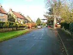
 Street in Knayton | |
.svg.png.webp) Knayton Location within North Yorkshire | |
| OS grid reference | SE432879 |
| Civil parish | |
| Unitary authority | |
| Ceremonial county | |
| Region | |
| Country | England |
| Sovereign state | United Kingdom |
| Post town | THIRSK |
| Postcode district | YO7 |
| Dialling code | 01845 |
| Police | North Yorkshire |
| Fire | North Yorkshire |
| Ambulance | Yorkshire |
Knayton is a small village in North Yorkshire, England. It is located north of Thirsk just off the A19. It is linked with the hamlet of Brawith, approximately 1-mile (1.6 km) away to the west.[1]
History
The village is mentioned in the Domesday Book as having four households, 100 acres (40 ha) of meadowland, and 75 ploughlands.[2] The name of the village derives from an Old English personal name (Cēngifu), and the Old English word tūn meaning town.[3][4] The Dog and Gun public house faces the village green and the village hall, whilst the village school, Knayton Church of England Academy, is on the western side of the A19.[5] The school was rated as Outstanding by Ofsted in 2017, and again under another inspection in 2022.[6][7]
There is also a caravan park and bus stop but no scheduled public service, just buses for schoolchildren.[8] Knayton is also the home of The Hillside Rural Activities Park (HRAP) with a cricket pitch, three tennis courts, two football pitches, and is the home of Borrowby show.[9][10] In 2012 The Willowman Festival was held on the park.[11] There is no church in the village, the nearest is at Leake, further north along the A19.[12]
Knayton forms part of the civil parish of Knayton with Brawith.[13] At the 2001 Census, the parish had a population of 326,[14] dropping to 318 at the 2011 Census.[15] In 2015, North Yorkshire County Council estimated the population of the village and parish to be 310.[16] The village is part of the Thirsk and Malton Constituency.[17]
References
- ↑ "302" (Map). Northallerton & Thirsk. 1:25,000. Explorer. Ordnance Survey. 2018. ISBN 978-0-319-24554-5.
- ↑ "Knayton | Domesday Book". opendomesday.org. Retrieved 16 November 2023.
- ↑ Smith, A. H. (1979) [1928]. The Place Names of the North Riding of Yorkshire. English Place Name Society. p. 206. OCLC 19714705.
- ↑ Ekwall, Eilert (1960). The concise Oxford dictionary of English place-names (4 ed.). Oxford: Oxford University Press. p. 482. ISBN 0-19-869103-3.
- ↑ "Review: Why I entered the Dog and Gun at Knayton with a degree of trepidation". The Northern Echo. 8 December 2018. Retrieved 16 November 2023.
- ↑ Chapman, Hannah (27 September 2017). "Village primary school given rare 'outstanding' rating by Ofsted". The Northern Echo. Retrieved 16 November 2023.
- ↑ "Knayton Church of England Academy URN: 144429". reports.ofsted.gov.uk. 25 July 2022. Retrieved 16 November 2023.
- ↑ "Bus services serving Knayton - North Yorkshire Council Public Transport Information". northyorkstravel.info. Retrieved 16 November 2023.
- ↑ Hayes, Julie (28 July 2011). "Hundreds flock to Borrowby Show". Gazette & Herald. Retrieved 16 November 2023.
- ↑ "Sun shines for 73rd Borrowby Show as crowds flock to celebrate rural life". Darlington and Stockton Times. 1 August 2023. Retrieved 16 November 2023.
- ↑ "Willowman Festival 2012 - eFestivals". efestivals.co.uk. Retrieved 16 November 2023.
- ↑ "History – St Mary's Church, Leake". leakechurch.org.uk. Retrieved 16 November 2023.
- ↑ "Election Maps". ordnancesurvey.co.uk. Retrieved 16 November 2023.
On the left of the screen is the "Boundary" tab; click this and activate either civil parishes or Westminster Constituencies (or both), however, only two functions can be active at any one time.
- ↑ UK Census (2001). "Local Area Report – Knayton with Brawith Parish (36UC088)". Nomis. Office for National Statistics. Retrieved 17 November 2023.
- ↑ UK Census (2011). "Local Area Report – Knayton with Brawith Parish (E04007213)". Nomis. Office for National Statistics. Retrieved 17 November 2023.
- ↑ "2015 Population Estimates: Parishes" (PDF). northyorks.gov.uk. December 2016. p. 11. Archived from the original (PDF) on 4 June 2022. Retrieved 17 November 2023.
- ↑ "Election Maps". ordnancesurvey.co.uk. Retrieved 17 November 2023.
On the left of the screen is the "Boundary" tab; click this and activate either civil parishes or Westminster Constituencies (or both), however, only two functions can be active at any one time.
External links
![]() Media related to Knayton at Wikimedia Commons
Media related to Knayton at Wikimedia Commons