| Komata River | |
|---|---|
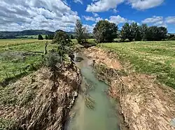 Komata River looking east from Hauraki Rail Trail after floods in 2023 | |
| Location | |
| Country | New Zealand |
| Physical characteristics | |
| Source | |
| • location | Coromandel Range |
| Mouth | |
• location | Waihou River |
| Length | 11 km (7 mi) |
The Komata River is a river of New Zealand's North Island. It flows west from the Coromandel Range, reaching the Waihou River just north of Paeroa.[1]
See also
References
- ↑ "Place name detail: Komata River". New Zealand Gazetteer. New Zealand Geographic Board. Retrieved 20 April 2010.
37°20′45″S 175°38′52″E / 37.345880°S 175.647780°E
This article is issued from Wikipedia. The text is licensed under Creative Commons - Attribution - Sharealike. Additional terms may apply for the media files.