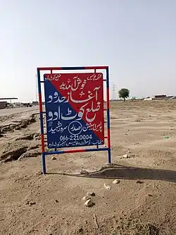
Kot Addu District
ضِلع کوٹ ادو | |
|---|---|
 A board representing boundary of district Kot Addu | |
 | |
| Country | |
| Province | |
| Division | Dera Ghazi Khan |
| Headquarters | Kot Addu |
| Government | |
| • Type | District Administration |
| • Deputy Commissioner | N/A |
| • District Police Officer | N/A |
| • District Health Officer | N/A |
| Area | |
| • Total | 3,471 km2 (1,340 sq mi) |
| Population | |
| • Total | 1,347,501 |
| • Density | 390/km2 (1,000/sq mi) |
| Time zone | UTC+5 (PST) |
| Number of Tehsils | 2 |
Kot Addu District (Urdu: ضِلع کوٹ ادو) is a district in the Punjab province of Pakistan. The district headquarter is Kot Addu city. Previously this district was part of Muzaffargarh District as Kot Addu Tehsil.[2]
Demographics
| Year | Pop. | ±% p.a. |
|---|---|---|
| 1951 | 143,009 | — |
| 1961 | 184,639 | +2.59% |
| 1972 | 313,137 | +4.92% |
| 1981 | 449,493 | +4.10% |
| 1998 | 808,438 | +3.51% |
| 2017 | 1,347,501 | +2.73% |
| Sources:[3] | ||
At the time of the 2017 census, Kot Addu district had 204,605 households and a population of 1,347,501. Kot Addu had a sex ratio of 953 females per 1000 males and a literacy rate of 55.25% - 66.89% for males and 43.10% for females. 254,147 (18.86%) lived in urban areas. 431,416 (32.02%) were under 10 years of age.[1]
| Religion | Population (1941)[4]: 62–63 | Percentage (1941) | Population (2017) | Percentage (2017) |
|---|---|---|---|---|
| Islam |
117,505 | 87.96% | 1,341,598 | 99.56% |
| Hinduism |
14,303 | 10.71% | 401 | 0.03% |
| Sikhism |
1,720 | 1.29% | — | — |
| Christianity |
52 | 0.04% | 5,059 | 0.38% |
| Ahmadi | — | — | 413 | 0.03% |
| Others [lower-alpha 3] | 5 | 0% | 175 | 0.01% |
| Total Population | 133,585 | 100% | 1,347,501 | 100% |
At the time of the 2017 census, 79.05% of the population spoke Saraiki, 11.97% Punjabi, 5.30% Urdu and 2.77% Pashto as their first language.[1]
Administration
The district is administratively subdivided into two tehsils.
| Name of Tehsil | No of Union Councils |
|---|---|
| Chowk Sarwar | |
| Kot Addu | 32 |
Notes
- ↑ 1941 figures are for Kot Addu tehsil of Muzaffargarh District, which roughly corresponds to present-day Kot Addu district. Historic district borders may not be an exact match in the present-day due to various bifurcations to district borders — which since created new districts — throughout the historic Punjab Province region during the post-independence era that have taken into account population increases.
- ↑ 1941 census: Including Ad-Dharmis
- ↑ Including Jainism, Buddhism, Zoroastrianism, Judaism, or not stated
References
- 1 2 3 4 "District Wise Results / Tables (Census - 2017)". www.pbscensus.gov.pk. Pakistan Bureau of Statistics.
- ↑ "Punjab CM approves establishment of four new districts in province". Daily Times. 15 October 2022. Retrieved 15 October 2022.
- ↑ "Population by administrative units 1951-1998" (PDF). Pakistan Bureau of Statistics.
- ↑ "CENSUS OF INDIA, 1941 VOLUME VI PUNJAB PROVINCE". Retrieved 21 July 2022.
This article is issued from Wikipedia. The text is licensed under Creative Commons - Attribution - Sharealike. Additional terms may apply for the media files.
