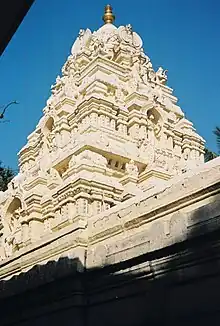
| Kote Venkataramana Temple, | |
|---|---|
| Religion | |
| Affiliation | Hinduism |
| District | Bangalore |
| Deity | Lord Venkateshwara |
| Location | |
| Location | Krishnarajendra Road, Bangalore |
| State | Karnataka |
| Country | India |
| Architecture | |
| Completed | 1689 |

Kote Venkataramana Temple is a Hindu temple in Krishnarajendra Road, Bangalore, India dedicated to the god Venkateshwara. The temple was built in 1689 in Dravidian and Vijayanagara style by King Chikka Devaraja Wodeyar, then ruler of Mysore.[1]
Temple plan
The late 17th century Venkataramana temple is located near the old fort ("fort" is kote in Kannada language) adjacent to what was once the residence of Mysore Wodeyar royal family, and later became the palace of Tipu Sultan, a later ruler of the Mysore Kingdom.[2]
The temple consists of a sanctum (garbhagriha) which is connected to a central hall (mantapa) by a vestibule. The walls of the sanctum and vestibule (antechamber) are plain but for a row of deity sculptures in frieze at the base. On the whole the temple exudes modest decorative work and follows the general plan used in the temples within the palace complex in Mysore. The hall ceiling is supported by pillars that have "clusters of colonettes" alternating with yalis (mythical beasts from Hindu legend) in all four directions. This appears on each of the central columns.[2]
The main festival celebrated here is Vaikuntha Ekadashi when thousands of devotees throng the temple.
This temple provided the setting for the treasure hunt in the book Riddle of the Seventh Stone[3]
Gallery
_in_Kote_Venkataramana_Swamy_Temple_at_Bengaluru.JPG.webp) Ornate mantapa (hall) leading to the sanctum in Kote Venkataramana temple in Bengaluru (Bangalore). Central Yali pillars support mantapa ceiling
Ornate mantapa (hall) leading to the sanctum in Kote Venkataramana temple in Bengaluru (Bangalore). Central Yali pillars support mantapa ceiling_pillars_in_Kote_Ventakaramana_Swamy_Temple_at_Bengaluru.JPG.webp) Close up of Yali pillar inside the mantapa in Kote Venkataramana temple in Bengaluru
Close up of Yali pillar inside the mantapa in Kote Venkataramana temple in Bengaluru_over_shrine_in_Kote_Venkataramana_Swamy_Temple_(17th_century)_at_Bengaluru.JPG.webp) A shikhara (tower) in the Kote Venkataramana temple in Bengaluru
A shikhara (tower) in the Kote Venkataramana temple in Bengaluru_in_Kote_Venkataramana_Swamy_temple_at_Bengaluru.JPG.webp) Yali pillar at Kote Venkataramana temple in Bengaluru
Yali pillar at Kote Venkataramana temple in Bengaluru
References
- Michell, George (1995) [1995]. The New Cambridge History of India, Volumes 1-6. Cambridge: Cambridge University Press. ISBN 0521-441102.
Notes
- ↑ S, Bageshree (9 September 2010). "Forgotten, but still holding fort". The Hindu. Retrieved 28 January 2011.
- 1 2 Michell (1995), p. 71
- ↑ Madhukar, Jayanthi (18 October 2010). "Into B'lore's underbelly". Bangalore Mirror. Archived from the original on 7 October 2011. Retrieved 29 May 2012.
12°57′34″N 77°34′27″E / 12.959524°N 77.574305°E
_over_shrines_in_the_Kote_Venkataramana_Swami%252C_Bangalore.jpg.webp)
