| Kronach | |
|---|---|
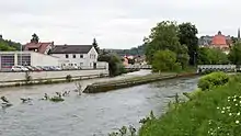
.jpg.webp) View from Kaulanger bridge in Kronach | |
| Location | |
| Country | Germany |
| State | Bayern |
| District | Upper Franconia |
| Reference no. | DE: 241446 |
| Physical characteristics | |
| Source | |
| • location | Source: Confluence of Kremnitz and Grümpel at Wilhelmsthal |
| • coordinates | 50°17′52″N 11°22′00″E / 50.297638888889°N 11.366666666667°E |
| • elevation | 356 m above sea level (NN) |
| Mouth | |
• location | Confluence: in Kronach into Haßlach |
• coordinates | 50°14′13″N 11°19′14″E / 50.236805555556°N 11.320555555556°E |
• elevation | ca. 305 m above sea level (NN) |
| Length | 7.94 km (4.93 mi) (with Kremnitz 27.6 km (17.1 mi)) [1] |
| Discharge | |
| • location | at Steinberg gauge[2] |
| • average | 1.7 m3/s (60 cu ft/s) |
| • minimum | Record low: 8 L/s (0.28 cu ft/s) Average low: 120 L/s (4.2 cu ft/s) |
| • maximum | Average high: 26.4 m3/s (930 cu ft/s) Record high: 58.4 m3/s (2,060 cu ft/s) (in 1947) |
| Basin features | |
| Progression | Haßlach→ Rodach→ Main→ Rhine→ North Sea |
 Confluence of Kronach (right) into the Haßlach (left) during the 2013 European floods | |
The Kronach is a river in Upper Franconia, Bavaria, Germany. It is about 8 km (5.0 mi) long and is formed from the confluence of the rivers Kremnitz and Grümpel, south of Wilhelmsthal. Including its source rivers Kremnitz and Finsterbach, the Kronach is 27.6 km (17.1 mi) long.[1] From there it flows in a generally southerly direction to its confluence with the Haßlach at the town of Kronach. The ST2200 road, which connects those two places, follows its valley.
See also
References
- 1 2 Complete table of the Bavarian Waterbody Register by the Bavarian State Office for the Environment (xls, 10.3 MB)
- ↑ Bayerischer Hochwassernachrichtendienst (as of 6. September 2011)
This article is issued from Wikipedia. The text is licensed under Creative Commons - Attribution - Sharealike. Additional terms may apply for the media files.